
Dec. 5, 2015
Doing a bit of writing as we approach the home place and already compiling a mental list of what is to be done when we arrive, and in what order. We have two parties to attend over the weekend, so we will definitely get a head-start on sociability, as if we didn’t have lots of that on this short trip.
Even as we were packing to leave our four-day stay spot near Parker, I ran into an old friend from Prescott. Sandy & Bob are work camping there; she & I arrived at the clubhouse door at the same time and recognition set in. They were active OLLI members back when I was administrator of that program at Yavapai College. We had a fun catch-up and likely will see each other again back in Prescott where they still have a home. Quite a bit of a coincidence for two Prescottonians to be in the same square yard at the same time at an RV park on the Colorado River.
That set our 9:30 departure back about a half-hour but well worth it. By then, we had the trailer’s contents packed into boxes for carting into the house, refrigerator/freezer emptied and cleaned and the trailer winterized, all of which will make our arrival at home a smooth operation.
George’s coats, inspired . . .
We have an extra component to our cargo: when we visited Norma and George in Tucson, the subject of one of George’s annual endeavors came up. Seems that he goes to sales throughout the year to purchase warm winter clothing to donate. His usual contact for distributing those much-needed items was not available, so we are privileged to take care of it.
That will be a top priority - the weather in our area has turned very wintery; there is no doubt there will be many who will gratefully benefit from George’s largess. I'm feeling very inspired by his charitable task, reinforcing the realization that we can all do something to be of service to our fellow man, thus making the world a better place.
Emerald Cove . . .
We lengthened our Thanksgiving trip to the Tucson area by bopping over to Parker for another four free nights at Emerald Cove, thinking thoughts of warmer weather; however, our timing was off weather-wise. It just happened that we were there during an area-wide cold snap. Yes, we avoided temps in the teens at home, but we remained pretty bundled up down in the desert.
 |
| Different birds, same result - we had to bring in the seed feeder; the grackles were much too plentiful, raucous and messy. |
 |
| Ring-billed gulls frequented the shore at the RV park . . . |
 |
| . . . and worked at gathering dates from palm trees. |
 |
| Boats only occasionally took to the river during out short stay, no doubt deterred by chilly winds and lower-than-normal temperatures. |
 |
| Even some of the folks like these who have attractive homes right on the water keep RVs to house them elsewhere during the region's very hot summers. |
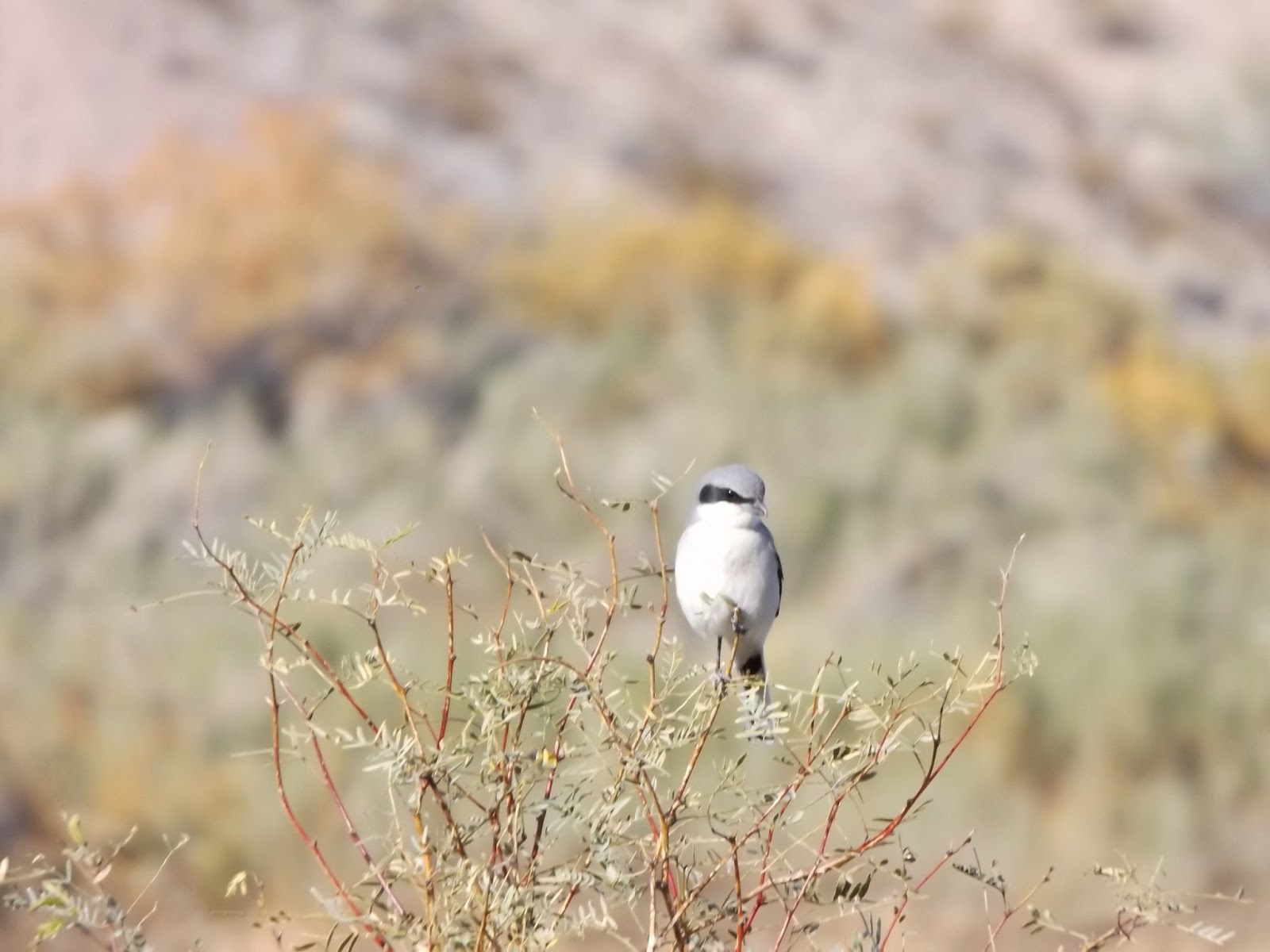 |
| The birding was very different from last spring when we were there. This loggerhead shrike was not new to the trip list, but at least he sat still for a portrait. |
 |
| Last March, this sere alkali flat was as wet as it is now dry and was teeming with many hundreds of waterfowl. We were excited to see what varieties were there in autumn; the answer, of course, was none. We were surprised to add so few species to the trip's bird list: whether this was typical for fall on that migratory route or the result of a dry spell, we don't know. |
Gibraltar Mountain Wilderness . . .
Our intention to kayak and fish dissipated with the chilly winds, but hiking was just the ticket to fill our time.
It took a few scouts to manage it it, but we found some excellent routes into the Gibraltar Mountain Wilderness Area and were enthralled with the stark stunning scenery all around us. Convoluted rock peaks of gargantuan proportions impeded our progress with lots of box canyons until we finally managed to traverse our way upward on some super steep slopes.
On one particularly steep climb, I began to slip and was in danger of rolling away somewhere whence I had come. In order to stay put, I had to stretch out on the ground; the slope was so vertical that I scarcely had to change my position to do so. Grateful that I didn’t fall, I got stabilized, dusted off myself, what was left of my dignity and my camera and continued on my way after a helpful hand up from the señor.
We shall certainly return to hike those spectacular mountains, a wonderfully alluring place. One intriguing sight was an American flag on a pole somehow planted many hundreds of feet on top of a very sheer rock monolith. As we viewed the peak from various aspects, we could see no possible access except by helicopter. It is hard to imagine a rock climber carrying flag and pole to that height. Whoever and however, I applaud their intent and tenacity - what a symbol!
 |
| That tiny speck just above the peak is an American flag proudly waving. How it was placed there is a monumental mystery to us. |
 |
| Much of that range features tortured and twisted rock formations pocked with holes, and little vegetation. |

 |
| That's us up there on one of those high narrow ridges that make my stomach churn at the precariousness, but that I continue to venture on to for some obscure reason. |
 |
| The Gibraltar Mountains possess a starkly rugged countenance that invites exploration. |


 |
| I LOVE these layers of shading! |


Planet Ranch . . .
Now that we know we can drive to the Bill Williams River rather than hiking miles of the last distance, we decided to do that and thus have ample time to explore upriver from the road access. No sooner had we started on that journey than we rethought our plan and veered off toward the Planet Ranch.
Now, evidently, a portion of the property has been deeded to Arizona Game & Fish Department for an eventual wildlife refuge in exchange for Freeport obtaining water rights in another area. I think I have explained that at least semi-right. At any rate, the land is not yet open to the public, which fact did not deter us from attempting to get to the river by only semi-trespassing, if there could be such a thing.
The property is heavily posted with signs about trespassing violators being prosecuted without going into specifics of just what that would look like. Not inclined to discover more about that possible consequence, we scrambled and bushwhacked and climbed and slipped along parallel to the fence until we were far enough to convince ourselves that we might be to the Bill Williams Wildlife Refuge beyond the ranch property. Scrambling under the fence brought us to more scrabbling and bushwhacking and climbing and slipping without ever being able to stand of the river’s bank.
The waterway seems to consist of a series of beaver dams and backed-up pools, choked with an incredible stand of willows, cottonwoods, tamarisk and other water-loving plant life. As we climbed up an adjacent cliff, we gained sufficient height to view lots of open water, but nary a foot of accessible shoreline. At one time, we got up close and personal with one bit of backwater, but even that was viewed only through thick vegetation.
 |
| Along the way we came upon a section of old road and what may have been a building pad for a smelter in the vicinity of building ruins and debris. |


 |
| Power lines stretch along the watercourse from the north to the Planet Ranch buildings. |


Copper mines . . .
Besides looking like fantasmagorical moonscapes, that region’s mountains are highly mineralized.

Near the Planet Ranch’s locked gate, we explored a warren of mine shafts and glory holes, in addition to building and camp ruins and dumps. Presuming they might have been from different eras, there were ruins of concrete, adobe and rock buildings.


Clearly, the ore that was sought there was copper: the rocks are of a beautiful turquoise hue, and because we . . . need . . . more . . . rocks, we brought some home with us.
 |
| Chris had to climb way on up yonder to obtain just the right stone specimens to take home because the thousands lying on lower elevations would not do. |


A fascination with burros . . .
We have enjoyed seeing many “town” burros, as I call them, sauntering and lounging in RV parks and on the roadways; this time, we were spotted by a pair of “country” burros. As I gazed around the mountainous landscape we were driving through, I saw them seeing us. We stopped for a photo op and you could have convinced me they were statuary instead of live animals as still as they stood. At long last, the older and wiser one (at least I deduced it was the senior of the two), ventured from its camouflaged spot to either get a better look or to show itself off more fully. I thought for a bit that she was going to come down to us, but she must have been too countrified for that.


Questing . . .
Another bright idea shot down: ‘tis the season for fresh dates, thought I, thus we could venture a bit more into California to purchase some just off the trees, while avoiding additional cold weather exposure. Our mission took us toward Blythe, but as is our wont, we were sidetracked here, there and the next place, and never did find the sought-after fruit.
Poston . . .
First stop was the Poston memorial of the infamous internment camp there during World War II. Nearly 18,000 Americans of Japanese ancestry were forced from their homes and imprisoned in basically unlivable conditions for 3-1/2 years, even while many of their menfolk were fighting and dying alongside other American soldiers. In all, there were 120,000 men, women and children interred in prison camps for the duration of the war.
A day of infamy was the Japanese attack at Pearl Harbor, but there is no doubt the forced relocation of tens of thousands of American citizens was a misguided result that stripped them of their citizenship, their homes and their businesses.

Colorado River Indian Tribes . .
CRIT is the acronym used for the Colorado River Indian Tribes and their reservation on which the town of Parker is located. In addition to many commercial enterprises operated by CRIT, their farmlands are extensive. From what we could see, the crops are primarily cotton and alfalfa; we stopped for a photo of one newly sprouted alfalfa field.

 |
| This water was also on CRIT acreage; we thought we might have some success birding there, but no such luck. |
 |
| I spotted several formations of birds like this that I was sure were ibises, but we never determined where they were roosting. All the marshy areas we previously encountered were gone to dry. |
Erk! That's the sound of us stopping suddenly to make a u-turn in order to go back to a point of interest. It would seem that Vidal, California, is a town no longer worthy of that designation, although a few households there are still occupied. The structure that got our attention was the J.M. Heacock Building, a handsome rock edifice of bygone years. Its construction included a petroglyph front and center surrounded by a collection of obviously hand-chosen stones.


The interior was divided into two sections and in good condition. I shot a photograph through a very dirty window to show an arched doorway in the rear.

The mysterious intaglios . . .
We were awed by the Blythe intaglios on an earlier trip and decided that since we were in the neighborhood, we would take another look. Since then, we have read about others that we have not seen but will try to track down in the future. They include human and animal figures and geometric or snakelike designs.
The geoglyphs are gigantic, formed unknown millennia ago on the desert floor by scraping away the darker surface rocks. They incurred damage from ATVers before they were fenced off by the Bureau of Land Management. Evidently, there are others that have not been secured but exist still despite it.
The forms are far too large to get a comprehensive look at them from the ground; the ones we saw are accompanied by aerial photos that give a clearer visual of the overall figure. The largest form is more than 170 feet tall.


 |
| In addition to having stupendous mountain ranges looming on every horizon, winter skies afforded awesome cloud formations and colorful sights like this sundog. |