Monday, September 28, 2009

Rescue and such
September 28, 2009


Today I risked life and limb (or at least being thought a fool) to save a turtle from certain destruction from compression, the result often referred to as turtle pancake. There we were driving right along and there he was crossing the road in the opposite lane. “Turtle, turtle!” I cleverly blurted out, and back we went, quickly reversing in the same lane until we were next to said creature.

I jumped out to effect the rescue, thinking that if another vehicle approached, Chris could drive away and leave me alone with my new friend. My new friend, however, had other ideas about my plan. As I ran around in front of the truck and into the other lane, Mr. Turtle appeared to attack, charging straight at me. He startled me so that I missed my grab. The not-so-slow-poke then commenced to gallop. I swear he made an amazing clatter, clatter, clatter as he hightailed it across the pavement to disappear under the truck.

That’s when I looked up to notice that a line of cars has stopped behind us. I’m not sure if they were laughing hysterically at my antics, but it seems like a good bet. I’m was still in the middle of the road peering under the Toter for the turtle, then tried the other side, peering under there for the turtle. At long last (probably not as long as it seemed), I spied him behind me galumphing off into the brush, no doubt grumbling about not being allowed to cross the road.

Needless to say, I didn’t get a picture of that hardshell, but I got a nice shot of one we saw on another day. The portrait subject was back in the woods on a partially submerged dirt road. I shall digress as to the reason for the road’s underwater status by paraphrasing the old song, “Oh, Susannah” - “It rained all night the day I came; the weather it was wet.” Truthfully, it only rained some the first night we were here, deluged the entire second night and squalled positive buckets on and off yesterday.


Hatteras lighthouse . .
.

Today is the first blue day we’ve seen - clear and windy enough that a long walk on the beach is tantamount to a full-body exfoliation. Not loving the skin we began the day with, we went ahead. The surf was very different than other days, all of them with pretty darn impressive seas.

My first afternoon, I walked, read, lolled and sat on the beach until the gale force blast coated every strand of my hair with salt enough to make it all stand straight out behind me, and to coat my spectacles to the point that I barely found my way home. Oddly enough, I found the afternoon to be absolutely exhilarating (unlike today that just hurt).

One day, we climbed to the top of the Cape Hatteras lighthouse, but were barred from venturing out the doorway onto the upper balcony because of combined rain and wind. I find it necessary to keep pinching myself to know I am actually on the Outer Banks (OBX as it’s referred to locally) in general and on Hatteras Island in particular.

These places have been so much a part of history and lore that it is a bit disorienting. The beaches are incredible, and what a great time to be here - no crowds or traffic, which they say is a bit daunting at high season.

This lighthouse was moved in 1999 to save it from an eroding shoreline. We learned some things we hadn’t known, such as that each lighthouse is painted its own distinctive pattern so that they can be distinguished from each other by day, for example, Hatteras is spiraled while another is diamond patterned. At night, they have their own light pattern to broadcast.

It’s interesting that the names of the early lighthouse keepers are the same names we see of many folks who have remained on the island. One of the common family names here is Farrow; one of the early keepers with that surname had the first name of Pharaoh (this was in the early 1800s, so we can’t blame it on those little hippie mamas of the 60s).

Wind surfing, kite boarding, surfing,
fishing . . .


I’ve sorted out the kite thing. Kitty Hawk kites are a brand, not a type. The major local sports are wind surfing, where one stands on a board holding onto its attached sail that propels a person zipping across the water, and kite boarding, in which the athlete has his feet placed into straps on a board and is transported again with wind power but in this case via a partial-parachute-type sail that is far above him. They both take great strength and agility and are fun to watch. The wind surfers look like so many single butterfly wings flitting across the water. The kite boarders do acrobatics like leaping and twirling in the air and coming back down on their feet (best case scenario).

The Sound is the primary place for those activities with its waist-deep warm water (at least near shore). I suppose it deepens farther out, but haven’t sorted all these things out yet. There is also the more well-known surfing and tons of fishing, both Sound- and surf-side. The beaches are dotted with fisherpeople: their extra-length poles anchored into white PVC pipes stuck vertically into the sand. One sees vehicles everywhere with various apparati(?) for carrying the long poles and other equipment. They stand vertically in front or behind the trucks looking like giant insect antennas. We’ve watched quite a few folks pulling in their catches throughout the day.

There are quite a few surfers on the surfside (naturally), but swimmers nil or nearly so. I have no idea if the rough seas are normal or unusual as a result of the wind. Perhaps we shall learn that later.

On my first afternoon, I was awestruck at the magnificent breakers. Just then, a woman about my age (okay, not so young anymore) who advanced across the sand in her swim suit and walked into the water. I was almost afraid to sit on the sand and she was going into the water??? At first, all was well. She was about knee deep and even that was forceful. I watched her slowly proceed and survive the first wave. Then came the second one, which knocked her flat and caused her brain to begin to operate once again. Out of the water she came, across the beach on her way back to safe climes. As she passed me, she noted, “Too strong” in what had to be the understatement of the century.

Drinking water, RVs . . .

The drinking water here is putrid, so declares Chris. I wouldn’t know because I gave up drinking the local water long ago while traveling. It’s the only time I use bottled water, just can’t stomach the various smells and tastes. Chris is perpetually just fine with all of them, until now, so I know this one must be especially noxious.

We toured a fifth-wheel here in the park because the owner, Elaine, practically insisted. It is very nearly the same as that owned by Frank & Pat, but with one major floor plan divergence. Beautiful and functional, especially when compared to our amazing shrinking trailer. It was a Heartland-manufactured RV, which was sponsoring a rally here. I liked it . . . a lot.

WWII off Hatteras . . .

One of my discoveries (Encyclopedic partner, E.P. already knew this of course) was about the spring of 1942, when German U-boats sank just about one ship per day for several months off the coast here, in addition to the mayhem they were creating all along the coast. The British stepped in to assist and in the process, also lost ships to them.

The reason this subject surfaced (no pun intended) was a marker I saw leading to the graves of some British sailors. That was odd enough that I had to find out what it was about. We stopped to venture into the brush to see what was there. We found two graves, one for an unknown Brit, the other named, but before we could continue into the outback where the others are interred, we were attacked by mosquitoes of a size I didn’t know existed and in gargantuan numbers. I fought back long enough to photograph the beautiful turtle that we spotted, but then ran for cover. Unfortunately, a sizable number of the monsters followed us into the truck, where we were forced to launch a counteroffensive.

Birds . . .

We’ve spotted the usual shore birds - sanderlings, willets, blackbellied plovers and ruddy turnstones - three gulls - herring, laughing and great black-backed (a new one for us) and three terns - royal, Caspian and common (also a life bird), in addition to two gorgeous kestrel hawks soaring over the dunes behind the beach.

Saturday, September 26, 2009

Going north
September 26, 2009


A fairly leisurely leave-taking this morning: on the road at 9 a.m. We couldn’t get to Cedar Island in time for the early ferry, so we had ample time to make it to the 2 p.m. crossing. This ferry requires reservations and upfront payment, no refunds, so one wants to be sure to get there by the half-hour before departure that is required. Otherwise, they give away your space.

Amazingly, it was already 85 degrees when we departed and now at nearly noon, it hasn’t changed - hot and steamy, partially cloudy with building thunderheads. Rain is forecast for tomorrow, then clearing. I’m so tired I would welcome a day off but would prefer to take my lounging sans wet.

We’ve wandered through miles and miles of swamp country today, passed the Marine’s Camp Lejeune, been conveyed over many very large rivers by bridge, and traversed a steady stream of small towns once we were outside the Wilmington area’s traffic, which is voluminous.

One of the villages, Beaufort, is celebrating its 300th year in 2009. Founded in 1709, it is only North Carolina’s third oldest town. Now I’ll have to look up which are older.

In our travels, we stop at just about every historic site and historical marker that we can manage, but are frustrated at North Carolina’s way of displaying their markers. To their credit, they have lots of them; however, they post them right at the roadside with no way to pull off and read them. The result is that I get a hint of what they say, but never anything more than a word or two. Makes me wonder what is the point.

To get anywhere around here off the single road heading north/south, you’d need a boat; all is either open water on the rivers, estuaries or sound, or what I guess I would term tidal marsh or salt marsh. This consists of small open channels meandering through solid hummocks of clumpy spiky grass-like growth. Seems as if it would be very interesting kayaking and fishing in there. Everything that’s not water or salt marsh appears to be impenetrable swampy jungle.

There is a lot of new development. Most of the residential areas are set up so folks have docks on the small channels that will take them out to the sound and/or open ocean beyond the barrier islands. Others, of course, are right on the larger waterways. I saw one new housing development that offered a free boat with the purchase of a building site.

As we progressed north up the coast, development of any kind ceased. For the last 20 or so miles, there was nothing but small houses in a rural setting, and graveyards. An oddity that I’m at a loss to explain: there are numerous tiny burying plots spotted all along the way. Why are none of them consolidated?

Cedar Island, the Carteret . . .

Our ferry departs from Cedar Island, which we access via two high bridges. The idea was to get out to the embarkation point, check in and get something to eat, and voila! it worked perfectly. The only business for miles is a restaurant right at the ferry’s dock. The menu was very limited, but who’s to argue. We met some other folks while hanging out waiting to load. Everyone’s in a party mood for their weekend jaunt or vacation, especially the feller next to us who is turning 42 today and is handing out cold bottles of fancy beer.


He lives in Morehead, just south of Cedar Island, and keeps a camper on Ocracoke Island. His daughter is traveling a bit farther, like us, to Hatteras Island, for the surfing contests.

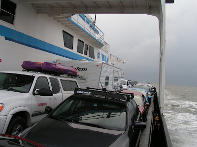
The Carteret, a toll ferry, is totally full: one car was turned away. I suppose they didn’t have a reservation. As we pull away to begin our more-than-two-hour crossing of Pamlico Sound, I am blown away (heh, heh) by the fierceness of the wind. That decides me not to remain outside, and didn’t want to stay in the passenger lounge because it’s rocking more there and because I thought Rowdy would be frightened.


I was wrong about Rowdy. Evidently, he has become so accustomed to the new and unusual that it didn’t faze him. “Oh well,” he appears to be thinking - “here we are jammed in with a whole bunch of other cars that won’t move out of our way, windows open enough to let in 40 m.p.h. wind, people wandering here and there, no land in sight, the truck rocking back and forth, and Dad sleeping in the driver’s seat. What’ll they think of next?”

Dare I tell him we have yet another unload, drive and load on another ferry, unload, and drive to finally get “home” before our day is over.

Blackbeard, the Cape Point, kites . . .

One of the infamous North Carolina historic markers was near the ferry landing, so I was able to actually read it. It was about the death of the pirate, Blackbeard, across Pamlico Sound in 1718. Now I’ve a yen to read up about him. Wasn’t his name Edward Teach, or was that someone else? We’ll find out.

Whew! What a ride that was to Ocracoke Island, pretty rough seas and outrageous wind. A short drive across Ocracoke, then we line up for what we think will be a half-hour wait for the next boat, a free ferry, when the Cape Point shows up almost immediately. We are directed onboard in the oddest way, guided to park straddling the line so that many fewer vehicles can be fit on. The couple in the other travel trailer, Deb and Dana from St. Joseph’s Island, Canada, are in the same situation on the opposite side of the boat. I have to say the crew people were extremely unpleasant and abrupt, seemed to be so rushed that they didn’t bother to park anyone correctly. Who knows what it was about.

Deb and Dana were here two years ago, are now on their way home after three weeks in Florida. He’s anxious to get a Kitty Hawk kite; he lost his last one in a tall tree in Washington. I will have to find out just what that is.

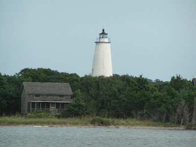
Skies are all gray and cloudy. We’re getting intermittent rain, and the temp has dropped to 79, chilly with the damp and wind. As we approached Ocracoke, I got a photo of the lighthouse. We will go to see the Hatteras lighthouse at some point.

By about 7 or so, we are worn out and happy to be at our destination. It appears from the map that we are just about as far east as you can get in North Carolina, in Rodanthe on Hatteras Island. I don’t know what the widest spot on the island is, can’t be much, but here it is narrow enough that our RV park fronts on the sound on one side and on the ocean on the other. What a setting!

Thursday, September 24, 2009

Yeeesss!
September 24, 2009

Oh my, an afternoon on the beach in the sun playing in the waves - it does not get any better than that. Our initial foray to the beach the day we arrived here was to Wrightsville Beach for a quick wade to assure ourselves the ocean was indeed still there.

Today, we tried out Carolina Beach: no particular difference except that there’s also a fishing pier at the one today. The sand was perfect; the water was perfect; the sun was perfect. It was just the ultimate relaxing perfect few hours.

Back home for a quick dip in the pool and a light supper of apples and cheese and crackers.

Tomorrow, we are bound for the Outer Banks, a place I’ve long longed to visit for no reason other than it’s got ocean and the name is intriguing. It’s quite a magillah to get there via long ferries, should be a stupendous adventure, and Rowdy’s first time on a ferry.

We did take him for a week on a houseboat on Lake Mohave once when we treated ourselves and the kids plus Sara’s friend Kelley to a spring break on the water. He had a great old time; I have a priceless photo of him lounging on the boat’s edge watching a loon floating off our starboard (or port or something) side.

Although the settlement density in this park is extremely low, we have gotten to know a couple of other travelers. The Canadians headed out for the Banks this morning. Another couple previously wintered on their boat in Charleston. When they decided that was a bit too much for them, they sold the boat and bought a small travel trailer (similar to ours) and have now begun to RV, but get this: they are 85 years old! Amazing!

Wednesday, September 23, 2009

Meeting the North Carolina coast
September 23, 2009


I had a good idea once; however, it was not yesterday when I decided to take back-to-back doses of Sudaphed before bed. (Note to self: thunk self smartly on forehead with heel of hand to remind self not to do that again). Wishing to look on the bright side of that action and its result, I was able to lie abed with eyes starting out of my head all night long to listen to the rain beating on the roof of the Totee.

The precip has scarcely relented since we arrived here. When there is a dry spell of a few minutes when we are home, I quickly open the hatches to get some real air in here. Shortly after, we find ourselves diving here and there to get them closed again as soon as it starts up again. I truly have never seen anything like it: one second it is not raining at all, and the next second it is POURING, POUNDING and BEATING down. I would be impressed if it had not become so tiresome.

We did get out and about some yesterday. A trip to the marina resulted in a nice talk with a fishing charter owner who we’d love to go out with (if it ever stops raining). He was kind enough to give us advice about places to launch our kayaks (if, etc.). There are great salt marsh areas that would be very fun to paddle, birdwatch and fish, and C wants to kayak out to Masonboro Island. I’m a bit dubious about the island excursion, but probably will agree to it (if . . .).

Fort Fisher . . .

We drove out to Fort Fisher, near the end of Cape Fear. It was an earthenworks Civil War fortification crucial to the protection of Wilmington (then the largest city in North Carolina) and the last port in the confederacy to fall to Union troops. Because of a pounding deluge of . . . yup, rain . . . we couldn’t walk the ruins (much of it is under the ocean now due to shoreline erosion anyway) but learned much in the museum/visitor center. It was the oddest museum I’ve been in, though. The lighting was severely deficient in many places, so much so that some of the material was unreadable.

Afterward, we ferried across the Cape Fear River’s estuary, a ride of nearly ten miles, and landed in Southport, a lovely small historic town, then drove home up the other side of the river. We had clear skies long enough to walk out on the fishing pier, where we enjoyed chatting with the men who were trying their luck. They were a friendly bunch, happy to explain about the fishing methods and answer our questions.


We awoke today to low dull gray skies, somehow not terribly surprising. It’s odd in a way because when we look outside, it looks cold, but is a perfectly comfortable temperature. We’re used to that wintry look being accompanied by bundling-up weather.

History replaces water . . .

Our original ideas for this area centered pretty much on water stuff - fishing, boating, beaching - but we’ve managed to punt and deal with it.


We enjoyed a nice walk (partly in the rain) along the Cape Fear River in Wilmington today, got an overview of the historical district via Clyde the trolley tour driver, had a good lunch on the river’s bank (but had to switch to other tables when we started getting wet) and toured the Burgwine-Wright house.

That was an excellent tour by a gentleman in Colonial period costume. The handsome structure sits atop an old Colonial jail foundation and itself is very old - built in 1770 - obviously the jail much older. We were able to go into the rooms that previously housed “cages” for prisoners and to peer into the dungeon that was the prison for the worst of them.

The oldest house still standing here was constructed in 1741. The history of Wilmington is fascinating, important as a seaport in the earliest days of the settlement of the area, since its founding in 1720, and back into the 1600s.

While waiting for our tour time, we got in lots of walking, all over the totally interesting and charming historic district. Beautiful homes and churches abound along brick and cobblestone streets shaded by magnificent Spanish-moss-draped trees.

We also snapped a pic of the U.S.S. North Carolina, a WWII battleship that saw much conflict, and is now moored in the river. We would like to tour her.

Sunshine, this ‘n that . . .

When we finished our house tour, we emerged into sunshine, liked to knocked me down it was so shocking. We squinted our way back to the truck and are thinking the siege is over.

Lots of folks here ride one-speed fat-tire bicycles, called beach cruisers. The land is flat, making these perfectly adequate.

Internet troubles at this park. The signal is excellent, but their server doesn’t like my sending server, so I have to transfer everything I send into webmail, which is a royal pain. Why can’t everyone just get along?

Grandma’s corner: Trinity Grace now has two teeth and although she just began to crawl, is overnight zipping around after her mom and dad.

The seed in our bird feeder has gone rancid and moldy, but this morning, we were still attracting a bunch of birds, including cardinals, Carolina wrens, Carolina chickadees and brown-headed nuthatches (a life bird for us).

Best business name (seen on a hot dog stand): Recession Concession.

Best innovative business: Cruise and snooze - a bed & breakfast operation on a boat.

Tuesday, September 22, 2009

We are drenched
September 21, 2009


Chris says the Arctic has permafrost and we have perma-rain, and so it seems. We hie ourselves away from the mountains with our nose pointed eastward to the leveler land toward the coast with great anticipation of seeing the sun.

It has been raining pretty steadily for five nights and five days, still quite a ways to equal Noahadic proportions, but more than enough for me. By telephone, Mom says Hendersonville, right by the RV park we left an hour ago, has flood waters nearly topping autos in places. I am grateful for nothing worse than hooking up this morning while standing in a pool of water with the falling precipitation reduced to a sprinkle for a while.

The incessant rain caused us to defer some activities certainly, but did nothing to diminish the pleasure of time with Mom and Dad. We also got to spend one evening dining out with the four of us plus cousin Will and his wife Charlotte, personable and fun companions. Much to my disappointment, the photo I requested to be taken by a waitress turned out just like last year’s pic of them - unusable. I must get a good photo on our return. That dinner out at Giardini’s was stupendous - everyone’s meal was outstanding - a must return for sure.

We have felt somewhat besieged during this stay. The leakage into the under-the-fridge cupboard once again reared its head and made a monumental mess of the bin’s contents. We had repacked that storage so that little was ruined except for boxes; however, it necessitated unpacking all of it with no place to put it except all over our already skimpy walking space.

This problem has been with us since last summer. The first time we thought it was a result of 11 days of pounding rain received courtesy of Hurricane Ike when we were in Fort Scott, Kansas. Clean up and move on. The next time, we deduced it must have been because of driving in the rain. Clean up and move on. This time, additional investigation via the loan of Dad’s ladder finally revealed the cause - a broken-off gutter spout that was clipped by the car wash mechanism last year in Denver.

At the time, that seemed such a minor matter: we had no idea it was related to our sogginess. Finally, fixes to the refrigerator compartment and the uptop vent not taking care of it, it was discovered by the process of elimination. Three trips to the RV parts place later, a short break in the rain gave us the opportunity to replace the part and eliminate the problem. We weren’t sure it was dry enough or dry long enough to effect the repair, but so far, so good.

Another loan from Mom and Dad - a spiffy ceramic heater/fan facilitated drying out of the soggy area, and plastic bins have replaced the sodden cardboard boxes. Everything is dried and restowed in its place, and our fingers are crossed. And the RV place has ordered our lost hub cover to be picked up when we return. Our lesson is to keep everything replaced and/or repaired at the time of its brokenness, no matter how minor it seems. And I shall purchase one of those tiny mighty heater/fans to carry in the Totee.

We filled the gas tank in South Carolina before departure. It’s standard operating procedure in those parts to bop across the border for fuel, encouraged by a whopping 26 cents differential between the two Carolinas!

Mom and Dad retired to Tryon, North Carolina, the same as his parents. The tiny town (1.8 square miles) is named after William Tryon, governor of North Carolina 1765 to 1771. It is nestled in the foothills of the Great Smoky Mountains. A charming little place, its residents’ homes are nearly invisible behind the trees and slopes and scattered along random winding mountain roads.

Our daily drive there takes us across the Green River Gorge where we are awed by the misty clouds hanging down among the trees. There are other routes that we take sometimes - one is the back road through Saluda following the Pacolet River down its gorge, also an awesome drive. Everywhere we look is natural beauty (and wet).

The vine that ate the South . . .

Unfortunately, this area, as well as many regions we’ve seen since Kentucky, also has the scourge of the South - kudzu vine, that large-leafed incredible grower that was imported for those very attributes, but which is smothering native foliage. It seems unstoppable, appearing as gigantic green living carpets covering all in its path. Bamboo, too, finds this climate ideal and appears as impenetrable forests in places.

John & Melissa, English dancing (or not) . . .

One evening, we were happy to visit our friends John and Melissa at their lovely home. Although both were recovering from colds, they treated us to Melissa’s fabulous chili and cornbread and a fun evening catching up. I’ve never quite forgiven them for moving from Prescott. Their first grandchild was due the day before we were there, but not anxious to make his appearance.

Their many bird feeders attracted purple finches, a life bird for us, among many others.

We intended to enjoy English country dancing with them on Sunday afternoon (John is the dance master), even stayed over a couple of days to do so, but when the time came, I couldn’t make myself go out again in the rain. It didn’t help knowing the trailer was in a flood plain and that the RV park had to be evacuated four years earlier due to flooding.

The getaway . . .

By midday, we are in nearly level country, full sunshine, and the forests have transformed into a much more evergreen, piney nature, probably due to sandier soil. After the past five days in the rainy mountains, it really is a relief to see some blue sky above and farther horizons.

The Tryon area was rife with vegetable and produce crops, as is this land farther east. Produce stands dot the countryside, but in this flatter terrain, we’re seeing additional field crops, even cotton. We began our day with blackberries fresh from the farmer’s field and topped them with cream - yummy!

The Atlantic . . .

A longish drive - about 3 p.m., we maneuver the traffic of Wilmington and locate our KOA home for the next few days. A very nice place, sparsely settled, with excellent accommodations. Set-up’s a breeze as we free the drenched awning to begin its dry-out. Some fiddling around and resting and then we’re off to find a beach, it being illegal to be this close and not put one’s feet into the salt water at the earliest possible moment. We were turned back at our first try: the map didn’t indicate we had to be an owner or guest to go out to that island. Private - humph!

Ahhh, at long last we have made it as far as we can go without a boat. Lovely beaches, great breakers with surfers astride their boards, few people. We walk in the warm water, always a welcome surprise to someone who grew up Pacific-side bracing for the frigid water of the ocean.

On our return stroll, we are treated to a sunset rainbow over the water. Now there’s something you’ll never see over California way.

Home, more relieved relaxing until about midnight when the skies opened up. Chris estimates several inches of rain pounded us in a few hours of much thunder and lightning, so much that I surrendered my life at one point, realizing it was absurd to fear the deafening bolts. Either one was going to zap me or it wasn’t, so I might as well calm down.

Day has dawned (well, not really) without rainfall, but also without sunshine. We will plan non-sunny-requiring activities for the day and hope it goes away.

Arizona, how I miss thee!

Wednesday, September 16, 2009

The wall, Flat Rock
September 16, 2009

I’ve finally hit my wall, that point at which changes must be made. At all times in my younger past, I have ignored the wall and proceeded to push myself whether it was absolutely necessary or not. Of course there are times when the situation warrants that extreme effort, but I did not previously recognize the difference, struggling to forge ahead simply because I could.

Well, I still can; however, I like to think that maturity has lent me a modicum of wisdom - knowledge that says to pay attention to my needs. Good ol’ maturity - it’s gotta be good for something.

In this case, my wall is that point that tells me to hit Chris over the head with the idea that we can’t live on the run every single day just because we are in the travel trailer. I have made a declaration: I require two days off every week in order to do life things, activities like writing, communicating with friends, dealing with paperwork, mail and other obligations, perhaps even something so decadent as sitting on the porch with my feet up - book in hand and iced tea at my side.

In Chris’ defense, he points out that it is I who never wants to turn back on that dirt road, who always wants to see around the next bend or over the next rise, who doesn’t want to miss one minute of one adventure. So we see that I am most likely asking him to apply my brakes. We shall see how this wall thing pans out.

We arrived at the Lakewood RV Resort in Flat Rock Friday afternoon. This is the same place we stayed last year when we visited Mom and Dad. Their home in Tryon is about 20 miles away, but this is the closest place to hook up the Totee. We like it very well, probably one of the nicest places we’ve stayed although the spaces are fairly small. They have a great swimming pool, large community room with piano and kitchen, pond and many amenities. They are also home to many full-timers in lovely accommodations, including a couple from Prescott and others with ties there.

Chimney Rock, John Mason

I’m writing as we are driving to Chimney Rock Park in hopes of watching the hawk migration. This has led us through the most attractive and inviting canyons and valleys I believe I have ever seen. Just passed through the village of Bat Cave and driving along the bottom of the rocky Broad River gorge with the river tumbling over its obstructed bed alongside us, canyon walls reaching far above. We have passed numerous farm stands, the primary produce being apples and something called mountain cabbage, which I suspect is no different than plain ol’ run of the mill cabbage. We shall avail ourselves of this luscious looking produce in the next day or so.

Now back home, I have spent the entire day exclaiming and pointing and carrying on something fiercesome. It was just that kind of place - the drive and hikes were stupendous. I loved the Hickory Nut Gorge, the mixed hardwood forest filled to brimming everywhere I looked with a great variety of skyscraper trees, none of which I recognize, and with thick understory foliage. flowers, ferns and all manner of greenery, again none of which I know.

At Chimney Rock, we entered a 198-foot tunnel drilled through solid rock to access an elevator. That conveyance took us up 258 feet, where we were able to walk out onto the top of Chimney Rock, and to see for endless miles through the blue mists, and down onto Lake Lure.

Naturally, it would never do that we stop at that, so we climbed 352 billion or so steps to get up to the newly opened Exclamation Point. Never in the entire time did we see a sign of a hawk migration, nor did we see any birds except one hummingbird and three vultures. It’s funny how this works, but after climbing those steps, we were required to descend in the same manner. By the time we were back to the bottom step, my leg muscles were dancing an odd little quiver that said “Don’t ever do that to me again.” I hope to heed that message.

Outside the gift shop atop the Rock we found a feller by the name of John Mason who is an accomplished player of the hammer dulcimer in addition to being an entertaining conversationalist. He uttered the best line of the day while we were discussing an oversized raccoon that lives at the site and is made large by tourists’ offering. The animal, by the way, he calls King Coon. Trying to pet a raccoon, John opined, would be akin to “arm wrestling with a circle saw.” We enjoyed his music well enough to purchase one of his cds.

When John learned that we hailed from Arizona, he recounted a memory from his only trip to our great state. Arriving in Yuma (sometimes the hottest spot in the nation) in July, he phoned his father to let him know how the trip was proceeding. Discussing of course the temperature, he said, “But Daddy, it’s a dry heat.” The elder Mason was unimpressed when he pointed out “Son, your mama cooks our Sunday chicken in a dry heat.”

Hickory Nut Falls

Eventually, we tore ourselves away from his witty repartee to retrace our steps down the elevator, out the tunnel and while unconscious from a knock on the head, found ourselves doing yet another hike. I know we must have been unconscious, else why would we have begun that trek. This time, it was a mile-and-a-half walk to the base of Hickory Nut Falls. The trail wound along the base of house-size boulders through shady forest to a gigantic rocky rubble partway down the nearly vertical gorge. Water was flowing down a solid rock face and then splashing over a rougher surface. We were much too close to get a photo of the entire 405-foot fall.

The trail was not a busy one, but one foursome we met said they had just seen a copperhead snake on the path where we were headed. I have never seen one, so hoped to get a glimpse, but never did.

Lake Lure

Legs still atremble, we let the Toter transport us down the road to Lure - the lake and the town - both of which I found completely enchanting. We dismounted and wandered an extensive lovely park that winds along two different fingers of the lake, and at its farthest point looks out on the larger lake proper.

A gaggle of geese walking the trail in front of us opted to take to the water and glided along looking for all the world like a little flotilla of surfaced submarines periscope up. We also got a wood duck, the first of the trip and after much discussion realized that other oddities we were seeing were female wood ducks, the first we have identified.

I had hopes of taking Mom and Dad out on the lake in a rented pontoon boat or on a guided tour; however, the cost and logistics make it impossible.

This is where I want my vacation home - right on the lake with a private dock. I saw the real me when I spotted a couple lounging on their waterside dock.

Mom & Dad

We’ve had wonderful visiting and expect to enjoy more. Chris played golf with Dad one day while I attended Mom’s Presbyterian women meeting and discussion group. We went to church with them on Sunday, after which fine dining included fare from Wendy’s. We’ve eaten at their house and they’ve eaten at ours. It’s been fun seeing some of their friends that we’ve gotten to know and meeting new ones. There is a wonderful circle of folks here that they have become close to and worked with in their multitude of activities.

The big news was that yesterday Dad received notice that he’s been chosen for the highest governor’s award for volunteerism. I shot some photos of him to submit to the newspaper for the announcement. Truthfully, I can’t imagine anyone more deserving. We are anxiously awaiting further information about it. I just got an email from the woman to whom I sent the photos who said the presentation will most likely be in November, so I guess we’ll miss it, much to my disappointment.

Chris and I wandered a cute “tailgate market”, a farmers’ market sort of affair. While there, I saw a sign informing that Bill Williams was born very near there in 1787. This is our very own mountain man Bill Williams who spent time in northern Arizona and who the mountain we see from our house, and the town near there, are named after.

Luckily, I cannot now remember all we’ve done since we’ve been here, so I can cut this shorter than if I had a better recall.

Best sign of the day: A person who aims at nothing is sure to hit it.

Friday, September 11, 2009

A $20 catfish, drowned rats
September 11, 2009 - A day of infamy

I start the day with time in memory of those many innocents who lost their lives in the September 11, 2001, terrorist attacks.

Now back to journaling, with gratitude to God for the opportunities I have each day and appreciation to those who have come before and sacrificed to make it possible.

A note to the wise: when in Kentucky: if you hear the weatherman forecast partly cloudy, plan to have your parade rained on. This is how it was for us two nights ago (seems such a long time). We get into the RV park at a tolerable hour, do a leisurely set-up, tend to chores, write blog. As it turns out, this park’s wifi works just fine for run-of-the-mill email but has a bandwidth limiting feature that makes internet activities go as slow as molasses in January in Nome. Soooo, while the blog is trudging uphill to load, I suggest we walk just a short way on a trail at the back of the park. It heads into the forest and is titled “lake trail”. I have no intention of hiking - way too tired - but would like to stretch my legs after driving for five hours. And besides, it’s already twilight time.

The trail is enchanting: mossy, damp deep woods, quiet except for crickets and other night critters. As is our habit, once started, we don’t want to stop, even when the route drops steeply. As we come out at the bottom, we find ourselves on the shore of a real lake. The most I had expected was a pond. We walk along the shore through the drippy foliage following the water that is not particularly far across, trying to get a feel for how far around it is and drooling at the appealing fishing opportunities it affords. Suddenly, someone speaks and scares the toot out of me. We have come to an opening in the brush and walked up to a small pontoon boat with three people aboard. Evidently, they are camping on it. The lady of the “kitchen” says she is frying (we’re in the South, remember) fish and potatoes and has cornbread in the oven. Where she might keep an oven on that platform is beyond me, but that’s what she said, and I believe her.

Finally, we head back at Chris’ insistence because it is dark and we have to climb out of this canyon on a gnarly, seldom-used trail.

The reason we were to spend a day in these parts was to hike more in Cumberland Gap, but after this foray, we threw over the ancestors in a New York minute, opting for fishing that little lake. We saw only a finger of it, but cleverly deduced that if those folks got a pontoon boat into it, we could launch our kayaks somewhere.

Of course now we will have to return to do the Gap stuff, but not this trip. We hiked to its summit last year and found it to be beautiful in its own right, but our excitement about being there stemmed from the knowledge of our many ancestors who undoubtedly traveled that identical path under their more trying circumstances.

Cumberland Gap was discovered in 1750; a route was pioneered there through the Appalachians by Daniel Boone and others in 1775. It was the primary route for westward movement from the Carolinas and Virginia to Kentucky and Tennessee until about 1810. It continued to be an important trail until the Civil War era, although other routes had been opened by then. The Gap was the route for families on foot, in wagons, and on horseback utilizing it, in addition to numerous freighters and drovers pushing herds of cattle, pigs and turkeys.

A partial listing of our ancestors who most likely set their feet on that trail with their families and all their worldly goods includes: Ezra and Lydia (Vance) Owen, John Chilcoat, Jacob Brown, John and Nancy (Brown) Hoppes, George and Elizabeth (Miller) Hoppes, Ann Weir (probably with her parents whom we don’t know), Mark Whitaker with his wife, Robert Whitaker, Joseph and Susan (McVey) McKinney, Jesse and Elizabeth (Cantrell) Bracken, Mary Cantrell after the death of her husband Jacob. Isaac and Elizabeth (Stalcup) Bracken, Thomas and Anna (Carr) Gentry, Gideon Carr (we have a letter he wrote about walking the entire distance from Albemarle County, Virginia, to Dickson County, Tennessee, at the age of 77), Daniel and Elizabeth (Rouse) Taylor, Samuel and Sally (Pipkin) Taylor, Lewis and Clemency (Hughes) Pipkin, James Colin McKinney. and possibly the Winans, Kelley, Means and Wallaces, in addition to a sizable number of others we haven’t found yet.

That background brings the place to life and creates a different atmosphere to hiking it.

Meanwhile back at the lake: we jumped in the Toter to check out how best to get the boats in the water. It certainly wasn’t going to be via that root-clogged steep trail of the night before. Surprisingly, we couldn’t seem to find lake access, but i did enjoy seeing several rural residential neighborhoods through which we searched. They reminded me of the area in which friends George and Mary live outside Danville, Kentucky. I was ready to put an offer on a house until Chris summoned me back to the task at hand. Finally, we were forced to ask directions, got all the skinny, drove to a boat ramp, drove back to the Totee, changed into swim suits, packed up and got over there just in time for the wrong time of day to be fishing.

We unpacked, equipped the boats, filled the dry bag, equipped us, and Chris drove the truck to the parking lot far above the ramp. While he was doing that, I got around to reading the Daniel Boone National Forest informational signs that informed us we needed to go to London, Kentucky (wherever that is) to obtain a discount parking pass that the feds deemed to be necessary in addition to our Golden Age pass that was prominently displayed on our dashboard.

A worrisome circumstance, now we hem and haw, draw zig zaggy lines in the dirt with our toes, clear our throats and try to decide if we want to chance a citation or towing(?) or if one of us wants to sit with the boats while the other climbs the stairway to heaven (it seems high enough anyway), gets the truck, drives to London, Kentucky (wherever that is), gets the parking pass and drives back to our bored-to-tears partner. In the end, we decide to take a chance.
paddling this way and that, fishing some, birding some (green herons, kingfishers and great blue herons everywhere) marveling at the beauty of the winding lake finger, imposing rock cliffs shoreside with trailing vines and dense tree stands atop. It’s a marvelous lake, Laurel by name, and we haven’t even seen a fraction of it. At 350 feet, it is Kentucky’s deepest lake. Its 5,600 acres are home to a huge range of fish - everything from rainbow trout and walleye, to crappie, bluegill and catfish.

Which brings us to the $20 catfish: our one-day nonresident licenses were $10 each. Late in the afternoon, the fish commenced to biting at which point I caught our first, last and only fish, a decent feisty catfish. Shortly afterward, as I looked down the lake, i spied a strange sight - a line beyond which it was pouring rain. Our side of the line was not precipitating, at least not at that moment, but that wall of water was suddenly upon us. I paddled like a mad person to the bank, jumped out of my boat and sheltered under the shore trees. Chris was taken a bit more by surprise and huddled over the camera and binocs in his boat. As I waited it out with rain running off my hat brim, I eventually sogged out so much that I began to sing and sway. The rain continued pouring down, deluging, pounding until I wondered if I would be spending the night standing there singing and swaying.

Early on, the thought passed through my brain that probably we had left our trailer roof vents open. I would have worried about it, but being fairly certain that water was pouring into the trailer, it seemed pointless to continue thinking about it.

I am unsure just how long it rained, knowing only that it was a substantial amount of time and that it would be impossible to get any more drenched. When it did relent, we quickly stowed the binocs and camera in the dry bag where we wished they’d been before it began, and started our return paddle. Thinking the fishing would now be fabulous, I made noises about trying our luck, thinking the storm was breaking up. Fortunately, the cooler head of our duo prevailed. Chris spurred us onward and I quickly got on that bandwagon just about the time it commenced to thundering. What is it about us, kayaks, lakes and storms anyway?

So once again, we ran for home - a paddle of two or three miles, which is way too long when thunder’s booming in the vicinity. At least this time it didn’t rain on us while we were underway; however, by the time we were loading up, it was running rivers down our heads.

What a relief to get back to the trailer and to get all dry and cozy - not. Indeed, the downpour was downpouring onto our bed and all over the bathroom. Getting soaked under these circumstances is trying, to say the least. There’s no place to put all the dripping stuff and there’s very little available to clean any of it up. The great news was that I brought my hair dryer which worked wonders for the blankets and mattress. Having no real choice, all the rest of it ended up either up dripping in the bathroom or was thrown helter skelter into the back of the truck to be dealt with at a sunnier time, hopefully this afternoon,

Today, we have been driving through the misty gorgeous forests of the Great Smoky Mountains. The views are stupendous and spectacular. The rivers are wonderful and beg to be rafted, which we will have to do at some point. I would love to spend a whole summer in Corbin and several more in the Smokies - really splendid country.

Of course we’ve skirted right through Tennessee into North Carolina, so a return to that land is a necessity. I had expected to visit cousin Chris there but have just discovered from him via Facebook that he is in South Korea teaching English.

And now we will be with Mom and Dad W. tonight - hoorah!

A quote from Patty regarding our foggy drive: Once the fog is gone, it's never mist.

Wednesday, September 9, 2009

A foggy drive, Kentucky
September 9, 2009


Pulling up stakes from our home of the past ten nights, we drive into pretty heavy fog or mist or whatever they call the lack of visibility in these parts. It’s been an interesting stay; I would love to spend a summer here, especially if the weather was like it has been this time. It’s 66 degrees at 9:30 a.m. Every day has been most pleasant.

I put too many pictures in yesterday’s blog and wrote it in too much of a hurry. Most of them are written hurriedly; I’m finding it a little frustrating not to be able to put more thought and energy into them. And I don’t understand why the blog site doesn’t allow users to scooch things around to where they want them on the page. Oh, to be a programmer (or whatever they now call people who put these things together). I set up each blog with photos placed just where I want them and then when I post it, everything scurries off into a different place. Even the preview it allows me bears no resemblance to either what I started with or what I end up with, so what’s the point of a preview? Ah well, the trials and tribulations. I put in all the photos because they were so fun, even if it did look dorky for them to line up that way. I hope folks know to click on them to get a decent look at them.

Somehow in the rush of getting it written, I left out one of the highlights of our stay here: we got ring-necked pheasants late yesterday while heading home. I had wondered aloud at one point why we hadn’t seen any in our travels across the Midwest. This flock was grazing the mowed area between a corn field and the road. We were traveling much too fast to be sure of their identity, so we had to turn around and go back, hoping for enough of a break in traffic to slow in the road and eyeball them. When we approached, they scuttled into the corn, but were near the edge where I could see them.

I really will miss this area. Never did get to any fishing, darn it, and not near as much casual exploring as I’d like. I love the wood lots that are throughout this region. No continuous forests like we’re accustomed to, but there is a wooded appearance anyway because every farm has one of more of the dense wood lots, abundant with diverse hardwoods. Thus the horizon is marked in every direction by handsome stands of mature trees.

This is a long driving day - 350 miles - to our stopover in Kentucky. We will remain there two nights, then bolt for North Carolina.

I’ve gone and joined Facebook, but now am bumfoozled about how to do anything on it. I got a cute note from Quinton and Loren greeting me and reminding me that they’re my slave children. An inside joke, but I sure could use my slave children here right now to show me how to reply to them. I shall stick with email and snail mail for my correspondence. Just thought Facebook would be another good link for the Goat Hill Music website. Now I need to get Chris to record more cds.

We were zooming along on one of Indiana’s bumpy, exceptionally narrow, winding state highways all morning, but got detoured here, there and the next place until it landed us in Ohio, the border we had been skirting along. The result was that we missed some Indiana territory we’ve never seen and enjoyed Ohio’s byway views instead. Our route was thus transformed so that we had to regroup, finally jumping onto the Interstate for the purpose of hightailing it through Cincinnati.

The East Ohio River was enticing and the Ohio was hugely impressive as it delivered us into Kentucky, our destination state. Later we were wowed by the Kentucky River.

We’ve finally gotten into hilly, forested country, beyond the reach of the glaciers, according to my E.P. (encyclopedic partner), some very prosperous historic small towns that make me want to get some local history of the area. It’s very attractive here, and I loved the campus of Miami of Ohio University, which we drove right through. The problem with living in many of these otherwise nice little communities throughout the Midwest is that they lack educational institutes and the many cultural opportunities that accompany them.

Via email, Katie reminds me of the remainder of the Sarah Prine (“These Is My Words”) trilogy. Actually, I didn’t know it was part of a trilogy. She highly recommends the other books, explaining, “The second one in particular, “Sarah's Quilt”, is where author Nancy Turner really hits her stride. There were thrills aplenty as well as laughs, sighs, tears, and so much with which to identify being a mother. The third and final book, “The Star Garden”, wraps it all up neatly . . .”.

Katie invited us to stay at their late 1800s house on Lake Maxinkuckee in northern Indiana while we were out here. It was tempting but didn’t fit in with our activities this time. We definitely want to get up there, hopefully while they are in residence. There are just so many things to see and do and learn (and very importantly, to fish).

At 3 p.m., we’re an hour out from our next home, traversing the wonderful rocky forested Kentucky mountains. Last year when we drove this stretch in late October, we were at a loss for words at the autumn beauty. What an experience that timing happened to be: we followed the fall leaf change for weeks from Wisconsin to North Carolina - it was way beyond awesome, something that couldn’t have been planned better, even though we didn’t plan it at all. Now, seeing this earlier in the season, it is equally gorgeous in a different way, with faint blushes on the mountainsides of red and yellow.

Since Cincinnati (try saying that three times fast), we’ve been driving the Interstate, efficient for getting somewhere but so much more boring than wandering through each and every small town, getting a much better idea of the lifestyles as they change from one spot to the next.

This mountainous region is so much wilder than anything we’ve seen since Colorado. Where there is agriculture, it is mostly hay, pasture and livestock, although we’ve noticed some tobacco still standing in the fields. This region makes the recently left behind sections of Indiana with miles and miles of crops and neatly mowed grass everywhere seem very civilized. I find the wild to be very appealing and intriguing.

After driving through dense fog for much of the day, we’ve now come out under light blue skies with towering thunderhead cloud formations reminiscent of Arizona. It has rained here today and may yet again.

And guess what - it did rain again, but not until the second we finished setting up, so all was good. A nice steady drizzle for a bit and then clearing. We are highly impressed with this RV park; it’s really well done and in a beautiful forested setting with a lovely pool that I won't be using. I like it better than most we’ve been at. This one’s a KOA also, in the town of Corbin, which I had never heard of, our abode for two nights with the day in between set aside for going to Cumberland Gap.

Tuesday, September 8, 2009

Limberlost Swamp, Loblolly Marsh
September 8, 2009


Departing under the threat of rain after a drippy early morning, we enjoyed a day outdoors with temps in the 70s and clouds gradually dissipating.

What a great hike we had in Limberlost Swamp and Loblolly Marsh, beautiful but insectful. I’m wondering what it is about marsh equals mosquitoes that I don’t understand. At any rate, the little whiner/biters were a problem only for a part of our time out there.

It’s a fascinating area, diverse with prairie, woods and swamps. We lingered long at a good-sized pond rich with bird life and turtles, lots of leopard frogs - green and black - hopping across our path. In fact, one landed on top of my foot, inspiring Chris to make some remark about “Rita shrieks with frogs”.

Everywhere we went today we heard many bird calls that were unknown to us. When all was said and done, though, we got only two new birds for the trip: a gray catbird and a yellow-shafted northern flicker.

Acres and acres of goldenrod were in full bloom, many types of head-high prairie grass waved sunlit seed heads in the soft breath of wind, thistles and myriad botanicals I’ve never encountered: it was lush and rich.

At every turn, we saw critters and creatures and flowers of all kinds and puffballs of a gargantuan size, impressive fungi of many kinds.

Which reminds me: did you hear about the mushroom that walked into the bar and ordered a drink. The bartender replied, “We don’t serve your kind here.” “Why not?” asked the mushroom. “I’m a fun-guy.”

After wandering trails throughout Loblolly, we explored wandering back roads through Amish country and the small town of Geneva, encountering horse and buggy travelers often. Chris had read about a covered bridge he wanted to see nearby. It is called the Ceylon Bridge for reasons I know not, and was constructed in 1860 - amazing that it stands still. Oddly, it no longer spans the Wabash River because the Wabash was channelized long ago to straighten out a meander and to accommodate shipping traffic.

It’s hard to imagine the Wabash at that point being navigable. When I see it now, I wonder about the ability to get even our kayaks any distance along it. We are told it was named for the Indian words meaning pure white water, but it is now a sluggish green slimy waterway. I can’t think this is the result of low water only because it has obviously flooded very recently, but still scarcely moves, and bears zero resemblance to its ages-ago characteristic of clear water flowing over white limestone.

Nevertheless, I’d love to fish the Wabash waters. When we hiked out into what’s called the Rainbow Bottoms, prairie land adjacent to the current channel within the area of its previous meander, we found little access to the river itself, but later spotted a river trail in the opposite direction that not only provided many places to get to the water, but also led us through deep quiet hardwood forest.

I really wanted to continue along the river; each turn of the watercourse beckoned me on, unfortunately, further exploration will have to wait until another trip here.

My puniness prevented us from doing all we wanted, but under any circumstances, we could not have done all we would like to here. Our journeying today took us to a place called Amishville, which includes an RV park that might be good to use for the next trip, which would put us in closer proximity to the Wabash and Limberlost.

Supper tonight was cornbread-stuffed tomatoes (the vegetables fresh from Jeff & Deb’s garden), a recipe I found in an annual "Southern Living" cook book, a gift from Melissa. It was delicious, made more so undoubtedly by the estimated four miles we hiked today.