September 26, 2009
A fairly leisurely leave-taking this morning: on the road at 9 a.m. We couldn’t get to Cedar Island in time for the early ferry, so we had ample time to make it to the 2 p.m. crossing. This ferry requires reservations and upfront payment, no refunds, so one wants to be sure to get there by the half-hour before departure that is required. Otherwise, they give away your space.
Amazingly, it was already 85 degrees when we departed and now at nearly noon, it hasn’t changed - hot and steamy, partially cloudy with building thunderheads. Rain is forecast for tomorrow, then clearing. I’m so tired I would welcome a day off but would prefer to take my lounging sans wet.
We’ve wandered through miles and miles of swamp country today, passed the Marine’s Camp Lejeune, been conveyed over many very large rivers by bridge, and traversed a steady stream of small towns once we were outside the Wilmington area’s traffic, which is voluminous.
One of the villages, Beaufort, is celebrating its 300th year in 2009. Founded in 1709, it is only North Carolina’s third oldest town. Now I’ll have to look up which are older.
In our travels, we stop at just about every historic site and historical marker that we can manage, but are frustrated at North Carolina’s way of displaying their markers. To their credit, they have lots of them; however, they post them right at the roadside with no way to pull off and read them. The result is that I get a hint of what they say, but never anything more than a word or two. Makes me wonder what is the point.
To get anywhere around here off the single road heading north/south, you’d need a boat; all is either open water on the rivers, estuaries or sound, or what I guess I would term tidal marsh or salt marsh. This consists of small open channels meandering through solid hummocks of clumpy spiky grass-like growth. Seems as if it would be very interesting kayaking and fishing in there. Everything that’s not water or salt marsh appears to be impenetrable swampy jungle.
There is a lot of new development. Most of the residential areas are set up so folks have docks on the small channels that will take them out to the sound and/or open ocean beyond the barrier islands. Others, of course, are right on the larger waterways. I saw one new housing development that offered a free boat with the purchase of a building site.
As we progressed north up the coast, development of any kind ceased. For the last 20 or so miles, there was nothing but small houses in a rural setting, and graveyards. An oddity that I’m at a loss to explain: there are numerous tiny burying plots spotted all along the way. Why are none of them consolidated?
Cedar Island, the Carteret . . .
Our ferry departs from Cedar Island, which we access via two high bridges. The idea was to get out to the embarkation point, check in and get something to eat, and voila! it worked perfectly. The only business for miles is a restaurant right at the ferry’s dock. The menu was very limited, but who’s to argue. We met some other folks while hanging out waiting to load. Everyone’s in a party mood for their weekend jaunt or vacation, especially the feller next to us who is turning 42 today and is handing out cold bottles of fancy beer.

He lives in Morehead, just south of Cedar Island, and keeps a camper on Ocracoke Island. His daughter is traveling a bit farther, like us, to Hatteras Island, for the surfing contests.
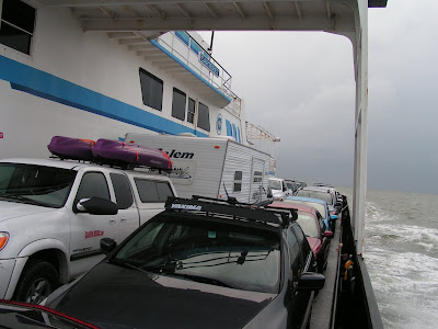
The Carteret, a toll ferry, is totally full: one car was turned away. I suppose they didn’t have a reservation. As we pull away to begin our more-than-two-hour crossing of Pamlico Sound, I am blown away (heh, heh) by the fierceness of the wind. That decides me not to remain outside, and didn’t want to stay in the passenger lounge because it’s rocking more there and because I thought Rowdy would be frightened.

I was wrong about Rowdy. Evidently, he has become so accustomed to the new and unusual that it didn’t faze him. “Oh well,” he appears to be thinking - “here we are jammed in with a whole bunch of other cars that won’t move out of our way, windows open enough to let in 40 m.p.h. wind, people wandering here and there, no land in sight, the truck rocking back and forth, and Dad sleeping in the driver’s seat. What’ll they think of next?”
Dare I tell him we have yet another unload, drive and load on another ferry, unload, and drive to finally get “home” before our day is over.
Blackbeard, the Cape Point, kites . . .
One of the infamous North Carolina historic markers was near the ferry landing, so I was able to actually read it. It was about the death of the pirate, Blackbeard, across Pamlico Sound in 1718. Now I’ve a yen to read up about him. Wasn’t his name Edward Teach, or was that someone else? We’ll find out.
Whew! What a ride that was to Ocracoke Island, pretty rough seas and outrageous wind. A short drive across Ocracoke, then we line up for what we think will be a half-hour wait for the next boat, a free ferry, when the
 Cape Point shows up almost immediately. We are directed onboard in the oddest way, guided to park straddling the line so that many fewer vehicles can be fit on. The couple in the other travel trailer, Deb and Dana from St. Joseph’s Island, Canada, are in the same situation on the opposite side of the boat. I have to say the crew people were extremely unpleasant and abrupt, seemed to be so rushed that they didn’t bother to park anyone correctly. Who knows what it was about.
Deb and Dana were here two years ago, are now on their way home after three weeks in Florida. He’s anxious to get a Kitty Hawk kite; he lost his last one in a tall tree in Washington. I will have to find out just what that is.
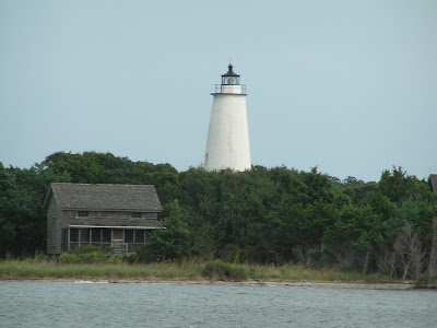
 Skies are all gray and cloudy. We’re getting intermittent rain, and the temp has dropped to 79, chilly with the damp and wind. As we approached Ocracoke, I got a photo of the lighthouse. We will go to see the Hatteras lighthouse at some point.
By about 7 or so, we are worn out and happy to be at our destination.
 It appears from the map that we are just about as far east as you can get in North Carolina, in Rodanthe on Hatteras Island. I don’t know what the widest spot on the island is, can’t be much, but here it is narrow enough that our RV park fronts on the sound on one side and on the ocean on the other. What a setting!

No comments:
Post a Comment