Friday, November 27, 2020

 A fave, a lesson & a correction/addendum

The fave is the Verde River - what a gift to the senses that waterway always is!  The Verde is so delightful as it carves its bed beneath rocky canyon walls, turning one way and then another way.  Its moods are as changeable as the seasons, fluctuating with the time of day and how the sun filters through the trees standing guard along its flanks.  

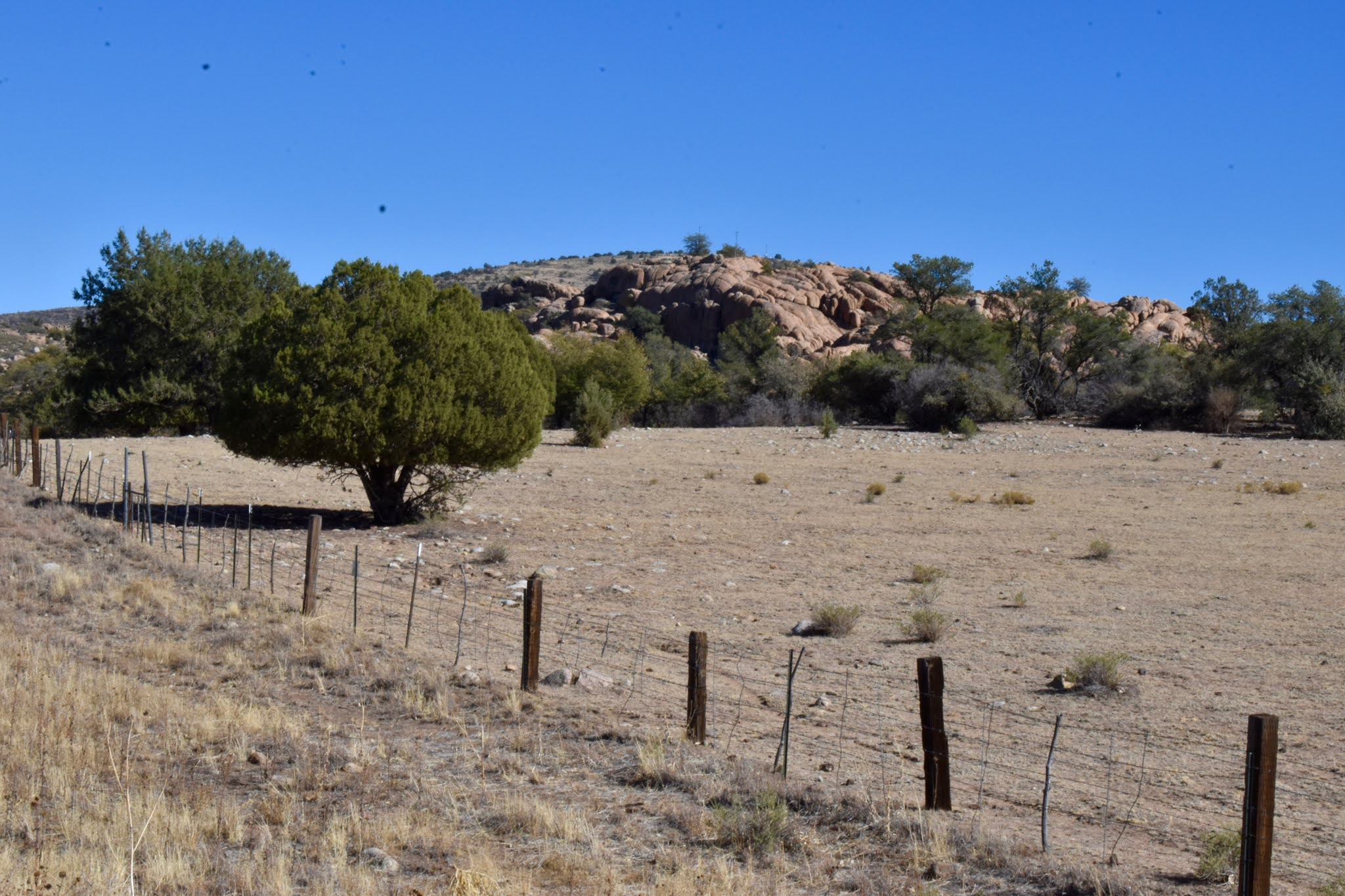
At one juncture, it may be a rushing stream running shallowly over the rocks it has polished to round smoothness, and at the next a wide placid pool of beauty enough to elicit a gasp at the sight as it offers reflections of its moisture-nourished brushy banks.

This week, we had the pleasure of another trek to the Verde, this time to the Stewart Ranch section.  Because that was a later vehicle-accessible spot, it is a bit of an easier walk down to the water along the ranch road than are most ways in.  That site is now administered by the Arizona Game & Fish Department, which has closed it off to motorized traffic, thank goodness.  The last time we were there, we saw ATVs running amok and even crossing the river while tearing up the fragile landscape.  Now all is quiet, and even with relatively easy access, few visitors.  

The lesson . . .

The low sun of late autumn made for lovely sights in the surrounding mountains and steep canyons, and that is where the lesson comes in.  For whatever brain-fogged reason, I failed to check my camera settings.  I snapped happily away and managed to ruin what should have been some stunning shots with that omission.  Disappointing for sure, but I strongly suspect I will not make that mistake again.

Little Thumb Butte is a prominent landmark there, visible for many miles from all directions.

The gravel road stretches from the parking area nearly to river's edge, but is a fairly steep descent.  At one point, we tried a more cross country route, but decided after a few slippy slidey scary spots that the going was getting worse enough that we turned back and resumed walking on the road.

The golden-leafed cottonwoods stood out in contrast to the dark rock cliffs and the green junipers.


Unlike some rivers where the banks are open, much of the Verde is overgrown with thick brush and reeds, making access very limited.  It takes a good bit of bushwhacking to get to most places along there, and even then, long stretches are just not accessible.  One especially inviting pool that we glimpsed down below kept us trying to find a way there without injury; however, we finally gave it up reluctantly and still in one piece.  

Cleared fallow fields attest to ranching and farming activity of the past.

We wandered for a few miles along the river, taking every opportunity to get to the water, and while we were at it, did a smidge of fishing.  The day's take included some small smallmouth bass, which of course we released.


Because it has been so long since we have had substantial rain, the Verde has filled in with more overgrowth along the banks and in the water; big floods tend to clear out some of that.

It was a sublime day to enjoy the gift of nature; that is until the climb out of the canyon.  One of us (who wasn't me) thought we could take a slightly longer route up from the bottom, and one of us (who was me) agreed that it was an okay idea.

As we climbed, we again surveyed the surrounding countryside with appreciation for the beauty.  An old corral across the canyon caught my eye and we also spotted a couple of rugged roads approaching from the south side - will have to see if/how we can come in from there.

Up we climbed, looking back whence we came . . .

. . . and wondering about the origin and use of a rock wall halfway up a slope.

All was well . . .


. . . until it wasn't.  Somehow, our slightly longer route became a much longer very rough trek uphill through a thoroughly unpleasant lava field strewn with catclaw and cactus.  As the culmination of a long hiking day, it was about as unfun as they come.


This is how much daylight that was left when we finally got to our car - none.

The correction/addendum . . .

In my last blog post, I was off on a tangent that somehow traversed the territory from Willow Lake to the historic Prescott Dry-Farm, as it was titled.  Further research and another walk along the Peavine Trail for an in-person look-see gave us lots more information.

Not to reiterate too much of what I've already written, suffice it to say we discovered that the U of A, in conjunction with the Prescott Chamber of Commerce, established an experimental unirrigated farm just north of Granite Dells.  I incorrectly surmised that property would be within the Arizona Eco Development's land that has requested annexation.  It is not; it directly abuts that property on its northern border.

But on to more interesting historical information about the farm.  It runs directly along the western side of what was then the Santa Fe, Prescott & Phoenix Railroad (now the Peavine Trail) and south from the current route of Highway 89A.  Our Thanksgiving day walk and a look at a 1911 map showed us that most of the Dry-Farm has already been developed.  

The site now includes commercial enterprises in addition to some houses; however, the big surprise was that the original barn and silo are still there and in good condition.


Most historical photos we've found of the farm, which was in operation from 1911 until 1927, show various successful crops, some of which we've never heard, such as koffoid, club-top and feterita.  

Of much more interest to us are the shots of the buildings and people.  The one that was taken during the silo filling is intriguing in several ways.  Two men are managing the operation on top of the silo, but I have no idea what the fascination is at the lower structure where people are peering into the interior.  

The best part, though, is the little child sitting in the wheelbarrow.  Did they use that for locomotion to bring him out there or did he climb in on his own or was it a way to keep him out of harm's way during the work?  Because that photo was taken in 1917 and our old pal and former Chino Valley Mayor Ted Bates was born there in 1915 while his father was farm foreman, I can't help but wonder if that is him.


The last picture clearly shows the railroad track running adjacent to the farm.  That is the one that Lucy Bates wrote about: when they needed water, they hung out a white cloth as a signal to the trainman who would then stop and fill their tank with water from Del Rio Ranch in Chino Valley.

Saturday, November 21, 2020

A few wanders & an Edventure

Bike trails . . .

After years of eschewing the many established trails in our region, the pard & I have begun venturing out on a few random walks that utilize those routes.  This map clearly shows why I prefer to wander the back country.  Just looking at that maze makes my eyes turn circles in opposite direction.  Fortunately, Chris is fine with mazes, and so we have set off a few times with all the other humans who are out there.

Because we have chosen our routes based on nothing more than knowing there's a trailhead over yonder somewhere, we seem to have ended up on some routes that are obviously engineered for bicycling thrills, thus lots and lots of bicyclists.  Sure does keep a person on their toes - no daydreaming allowed when one of them comes around a bend.  Our bit of experience is that they are good to announce themselves via bells, whistles or voice to give us time to move aside.  I must learn not to step back into the trail immediately afterward, though, because there is often another right behind.

In general, I will try to avoid the trails favored by bikers, but certainly can see why they enjoy the ups, downs and dipsy turns.  This week, we walked trails that head off from Iron Springs Road, and were rewarded with some wonderful countryside and views.  The chaparral in that section of our forest is so thick and tangled that it would be next to impossible to get through it if routes had not been cleared to facilitate access.


The bed of the now defunct railroad that ran through Iron Springs on its way into Prescott allows easy level walking for those who prefer that to the thrills of bike trails.  The photo below shows a tunnel beneath the railroad.

As we made our way through there, I remarked that I was sure a bicyclist would necessarily debark and walk through.  I was immediately proven wrong when one came along and entered without hesitation.  He tucked in his elbows, ducked his head and never even hesitated.

This is the view of Thumb Butte you would have had as a train passenger approaching Prescott from Iron Springs.


And then there is the Prescott basin spread out with Granite Dells, Glassford Hill and the Black Hills Range in the distance. 

The unseasonably warm weather we are enjoying so much is evidently what kept this tarantula from his hibernation hole where I would have expected him to be this late in the year.


Willow Lake, tales from history . . .

Our home location is so convenient to such varied terrains and environments that it's a joy to spin the dial and choose any direction.  Five minutes from home, we can be at either Willow or Watson Lake, and I never tire of either, savoring their similarities and their uniqueness.  


The dearth of summer rainfall has resulted in Willow Lake's water levels dropping, which in turn changes the shore line.  As we walked at Willow this week, we saw concrete foundations that are sometimes under water.  I wished I could know what they are from . . . and here we go off on another history tangent. . .


That wondering led me to think of an old friend, Theodore Bates, who was once upon a time mayor of Chino Valley.  Ted long ago told Chris that he went to school at a place he called Pleasant Valley, and that the site is now covered by Willow Lake, an impoundment that was created in the 1930s by the Chino Valley Irrigation District.  I have always wished to know about that school house and whatever other buildings and/or houses might have been there.

Toward that end, we perused a USGS map from the early 1900s, where we saw that structures were indeed there.  From the federal censuses, we discovered that the Bates family, among others, were residing in what was called the "Granite Dells Precinct" in 1920 and the "Prescott Justice Precinct" in 1930.  By 1940 of course, the dam had been built and the area flooded; by then, Ted was in "Chino Valley Village". 

The Bates family, dry farming in the Dells . . .

After noticing many familiar names from local history in those census pages, I took a peek into the Bates family section of Ellen Ginn's marvelous tome, "Cowchips & Calluses" to look for further enlightenment.  There I found a fascinating excerpt from a history written by Lucy Bates, Ted's mother.  She explained that her husband, Laron had been hired by a joint effort with the University of Arizona and the Prescott Chamber of Commerce to run an experimental dry farm less than a mile north of Granite Dells.

The section that the Bates family farmed is currently slated for development by the Arizona Eco Development firm, which has requested to be annexed into the City of Prescott. 

Part of Lucy's history about their 1911 venture follows. "When it got light the first morning at the farm and I looked out at where we were, I thought what a lonesome deserted place.  No trees or bushes.  A two room house, a small tank up by the railroad track where when we wanted water we hung out a white cloth and the train would stop and fill the tank with water.  The water was hauled from Del Rio Springs.  We had a wood stove, coal oil lamps, outside toilet.  We bathed in a tin tub, heating the water on the wood stove in a tea kettle.  Did our washing on a washboard and tub.  To get groceries or mail, we had to drive seven miles with our large work team, Hector and Ajaz, and a one-seated buggy to Prescott.  We went up Granite Creek to Granite Dells and crossed the railroad track at Fort Whipple.  It would take all day to get there, do our shopping and get home by dark.  

I was really lonesome at the dry farm.  I had come from a home where I had a sister, father and five brothers, to just us two and a hired man.  Our nearest neighbor lived about one mile from us, John Duke and his daughter, Mamie.  They were there only occasionally.  They spent most of their time at the St. Michael Hotel in Prescott, which they owned.  

Bianconis lived on an orchard two miles across Granite Creek.  They had lots of fruit and I learned to can.  They had a family of three boys and one girl, Jim, Bill, Elmer and Kate.  We liked them and had some good times together.

We liked the Woodmanseys from P & E Junction (me - this would be on the Peavine Trail at what is called Entro in the heart of Granite Dells).  He worked on the railroad as a section boss.  Mr. & Mrs. Bill Storm and boys,  Billy and Keith lived on the ranch and Mr. Storm took care of cattle . . . Mrs. Storm's mother and stepfather, the Littles, had a Dry Farm seven miles north of us.  We had to travel  by team and buggy, so didn't visit much."

And so that was rural life here just over one hundred years ago - fascinating to read, especially since many of those families' descendants remain in our area.

That dovetails rather nicely into a hike the seƱor & I just took along the Peavine Trail up to Entro, even though I knew nothing of the connection at the time.

Bradshaws Edventures, Granite Dells . . .

We have just completed filming our fifth Edventures virtual tour for Yavapai College, and our origination point just happened to be at Entro.  That six-mile hike along the Peavine is one we are very familiar with and always enjoy, but of course this time, we did some instructional filming at the site of the junction of the Santa Fe, Prescott & Phoenix Railroad and the Prescott & Eastern Railroad that Lucy Bates referred to.

That railroad bed is now known as the Peavine Trail, one of the most popular hereabouts, a nicely done Rails to Trails project.  Note the S.F., P&P Ry. sign below - the Santa Fe, Prescott & Phoenix, and imagine the train rumbling along through that rock cleft.


Desert enclaves . . .

In our newest Edventure, Chris chronicles the stories of early pioneers and prospectors, miners and railroaders who came to the southern Bradshaw Mountains looking for riches and how they overcame substantial obstacles in the process.

The story continues along the eastern flank of the mountain range, low in the desert with gold prospectors along the sparse waterways there, such as Bumble Bee Creek.

A desert settlement . . .

I shot a few photos while we were filming Chris' tales of the history of Cleator, a scattering of ramshackle wooden buildings along the road to the mountains.  I don't know what the population is, but certainly there are folks residing in those primitive structures and who are completely happy with their relative distance from the more frenetic existence that many of us have chosen.


The Cleator Bar & Yacht Club is alive and well, and sporting a brand new "yacht", the Black Scorpion.


Along our long rutted dusty route climbing into the Bradshaws, we took opportunities to halt at various overlooks and historic sites.  Chris told the tales of the struggles early prospectors encountered as they wrested valuable minerals from the mountainous terrain. 


Bradshaw City . . .

An early mining camp founded in 1863 that consisted of as many as 5,000 people is now nothing more than a few rock foundations; even the Forest Service sign that previously marked the spot is there no longer, undoubtedly having found a new home in someone's back yard.


As our Four Runner took us farther along the twisting and switch-backing railroad bed that now serves to get vehicles up the mountain, we were as always thrilled with the distant views.  At one point, we could actually see Bill Williams Mountain and San Francisco Peaks far off in the distant haze.

Hearing the history of the region enhanced the experience immensely, and helped just a bit with my fatigue from the bone-jarring journey as I unloaded, filmed and reloaded our equipment time after time.


The Algonquin Trail that begins high on the steep slope of a canyon above the Castle Creek Wilderness Area and drops down into Hell's Hole in the Poland Creek Canyon appears to be a pretty steep hike, as is pretty much everything up there in that rugged terrain.  I read some remarks at the trailhead sign-in; one basically said something along the lines of: "Hell no, turn back now!"  My sentiments exactly.

The small historic burg known as Crown King is the primary destination for those who utilize that road.  It is especially popular for ATVers.  We stopped there, of course, for Chris to relate more of the area's history . . .

. . . and continued on to Horsethief Basin, not accessible except via four-wheel-drive or high clearance vehicles.  It is designated as a Forest Service recreation area, but oh that road!  I suggest recreating elsewhere unless you enjoy beating up your vehicle and yourself.

We took some time off while we were there for a nice hike and to enjoy the small picturesque lake.


In my younger days, that road was maintained, which made Horsethief Basin a favored summer cooling-off place for those of us in desert climes.  It's a shame that it has not been kept up because the mountain is wonderful exploring territory.  On the other hand, the numerous forest fires up there would likely be even more if the general hordes could easily get there.

It was an extra special treat for us when a bald eagle swooped over the lake while we watched and perched in a ponderosa at the waterside.

As we returned on our way down the mountain in twilight, we were again treated to a view off to the east that looked more like a watercolor painting than a photograph.

Be sure to watch the Yavapai College non-credit department for the release of this latest Edventure.  Our previous virtual educational tours are available there at https://www.campusce.net/yc/category/category.aspx?C=&S=30.  See you there!