
July 2, 2017
As Chester A. Riley would say: "What a revoltin' development this is!" We have parked our trailer home in the Rancheria RV Park, a nice forested site with birds aplenty, for the purpose of the opportunity to hike within volcanic activity on Mt. Lassen. A plan that has been years in the making, but one that was foiled by Mother Nature.
In the process of ending California's drought, Ma N. got a little carried away by depositing as much as 40 feet of snow on Lassen's flanks. The upper trails are typically open by this time in the year; however, the accumulation proved too much and the schedule will not accommodate my best-laid plan.

I am disappointed, but find that it is not world-ending; we can return another year when conditions are more cooperative or at a later season, although I suspect the weather window is relatively short.
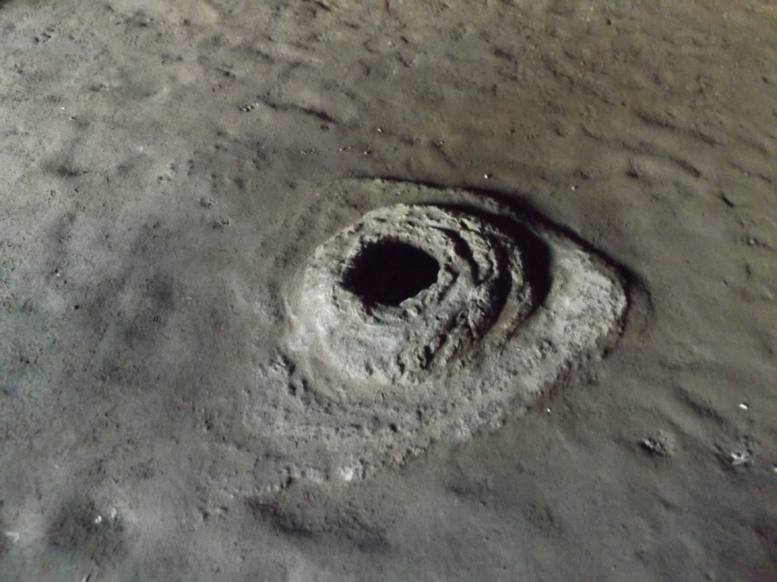
Bumpass Hell was the section of the mountain I had chosen for my wanders through mud pots, fumaroles, sulphuric gas eruptions and whatever other hydrothermal activities would be at hand. At present, we are told that Bumpass Hell's parking lot is surrounded by ten-foot walls of snow.
Named for its discoverer, Kendall Bumpass who sustained a severe burn in the exploration process, the place is now accessed (well, sometimes) via boardwalks that visitors are admonished to follow lest they suffer a similar fate.
Until Mount St. Helens blew its top, Lassen was the only active volcano in the contiguous 48 states. I have been up and over Lassen on the highway and wandered a bit up there amid the sulphuric springs, but have long longed to return for more extended explorations.
Absent that opportunity, we hiked at the mountain's foot and enjoyed the interesting museum with photographs and exhibits from the 1915 eruption. A local resident, Benjamin Loomis, risked his life to take photographs during and after that eruption. Other residents of the area recorded the cataclysmic event and how it affected them and they are quoted extensively in the museum.
 |
| This tiny structure houses the fascinating seismograph (below) built by Benjamin Loomis to record earth's movements at Mt. Lassen. |

The beginning (excerpted from Science Magazine 20 May 2015): "On May 14, 1915, people in towns as far as 20 miles away began to notice that the summit of Lassen Peak was glowing. That glow was from a small tongue of lava that was emerging from a crater at the summit of the volcano. For 6 days, lava slowly filled the crater and by the evening of May 19, the lava spilled out of the top of the crater and glowing boulders of hot lava rolled down the slopes of Lassen Peak. Later that night, the fireworks really began. An explosion rocked the volcano and, thanks to a snowy winter, all that hot volcanic debris encountered ~10 meters of snow on the upper slopes of the volcano. This created an avalanche of volcanic debris and snow that careened down the volcano, ripping up everything in its path. This flow was somewhere between a pyroclastic flow and a volcanic muddled (lahar), but too cool to be the former and too dry to be the latter. As it travelled down the slopes of the volcano, it created what is called the "Devastated Area" on the flanks of Lassen Peak."
Lassen erupts (continuing) . . .
"That explosion and resulting flow on May 19 was only the precursory event before the main show. By the morning of May 20, new lava arrived in the vacated summit crater. Just like its predecessor, the lava filled up the crater slowly until the middle of the afternoon on May 22, 1915. Then events went sideways. Pressure that had been building beneath the dome finally was too much to hold back and Lassen Peak exploded. The volcano produced a volcanic plume that went upwards of ~10 kilometers (30,000 feet) in only 30 minutes. The plume was spotted as far away as Sacramento (200 kilometers south) and Eureka (230 kilometer west), while the ash itself was noticed falling as far east as Winnemuca in Nevada, over 300 kilometers to the east. This blast produced its own pyroclastic flow/mudflow that travelled 5 kilometers further down Hat Creek than the May 19 flow, along with smaller mudflows that cascaded down the other slopes of the volcano (but didn't travel nearly as far). Near the volcano, 30 centimeters of pumice and ash piled up. The eruption was spectacular – and one of the first in the U.S. to be caught on camera as the many images of B.F. Loomis and others show. Loomis captured important images from before and after the May 19-22 eruption and without these images, many of the details of the eruption might have been lost."
Chris and I hiked in the so-called devastated area; however, these hundred or so years later, the forest has recovered to a great extent.
 |
| This 300-ton rock was blown five miles to this site during the 1915 eruption of Lassen Peak! Loomis reported it was hot to the touch three days later. |
 |
| Views of Mt. Lassen as seen from the Devastated Area. |

Subway Cave . . .
Enough of those adventures in the out-of-doors: a lava tube aptly named Subway Cave was our destination of one afternoon. We donned our headlamps (free of charge from Harbor Freight and worth about that much) and carting a flashlight, too, we entered the nether regions and stumbled our way along. Rough footing I can deal with, but man oh man, doing so without being able to discern what it is one is placing one's feet on is very interesting. Holding hands and utilizing extreme caution, we traversed the tube while remaining upright.


It is amazing to think of that entire space being filled with molten magma flowing along as the outer surface cools while the interior continues to flow, leaving the hollow tube through which we walked.
 |
| Hahahaha! Who could resist this roadside sign that a spelunking opportunity awaits. |
The coolest thing ever (until the next thing that is the coolest thing ever) . . .
Whilst wandering the byways of Lassen National Monument, we spotted a dotted line on the map called Emigrant Trail. It was not one of the designated hiking trails, but the temptation was great. We read about its interesting history at a roadside kiosk and decided to see if we could find it, and find it we did.


Judging by the map's dotted line, we wandered off through the forest until we located the mid-19th century route taken by thousands of pioneers westward bound for the Sacramento Valley. The trail is named for the man who discovered and built the road - William Nobles.
A Minnesotan, Nobles managed to persuade the U.S. Congress to appropriate a whopping $300,000 for trail construction, but despite the route being more gentle to traverse than other roads, the Noble Trail never became a major route. Noble's road was also known as the Fort Kearney, South Pass and Honey Lake Wagon Road (note the Honey Lake mention in a previous blog post).
It was the coolest thing ever to locate and follow along that route, thinking about the many, many folks who braved the unknown and myriad hardships to pack up their belongings and labor for so long to have a new beginning and a new life in a wilderness.
I was in awe as we hiked along the trail! What a wonderful chance to walk the route while enjoying the beauty of our surroundings. We followed along for quite a distance until after we crested over the divide and the road began switchbacks to drop off the mountain.
We have hiked on a few other pioneering wagon roads and enjoyed each one, including Cumberland Gap and the Natchez Trace. There's just something about following in the footsteps of those intrepid individuals . . .


Loaded for bear . . .
Please note that on this hike in the back woods, I was fully loaded for bear: bear bells jangling away lest we startle a bruin, air horn tucked into my front pocket from which it was easily extractable, and bear spray in its handy holster ready for quick deployment should it be needed.

Not one, but two life birds!
We were amazed to identify two birds to add to our life list, and both of them right at the RV park, although we spotted the red-breasted sapsucker in several other places, too. The other life bird was a white-faced woodpecker. A pair of them were working very hard in tandem at the base of a Jeffrey pine.
Others added to the trip list are great blue heron, wild turkey, California quail, white-breasted nuthatch, mountain chickadee, evening grosbeak, black-headed grosbeak, osprey (one in a nest with babies), black-capped chickadee and red-breasted nuthatch.


No comments:
Post a Comment