Utah!
Sept. 16, 2014
Mule Canyon, Comb Ridge, Butler Wash, Edge of the Cedars, Manti-La Sal National Forest, Arch Canyon, Cave Canyon, John’s Canyon, Recapture Lake: A small sampling of the vast territory that begs to be explored in the Blanding/Bluff region. We gave it a shot during our week there; a lifetime would not be sufficient to experience the place.
Fort Bluff, Hole-in-the-Rock settlers . . .
I did get to relieve my frustration at not having the time to photograph the wonderful historic buildings in Escalante by taking a little loop tour in Bluff after visiting the Fort Bluff museum. The site memorializes the settlement there by Mormon pioneers at the conclusion of their daring Hole-in-the-Rock expedition, a feat that defies belief in its audaciousness.
Descendants of those intrepid trailblazers have built replicas of the original cabins, tiny log dwellings constructed side by side facing inward around a square area; the circumference was secured by fences connecting the buildings.
What a feat the colonists accomplished in their quest to settle the San Juan area, carving out a wagon trail through the seemingly impassable escarpments and plateaus of the Grand Staircase-Escalante. They toiled ceaselessly for more than six months to carry their party approximately 250 miles.
At the outset, the task was expected to involve six weeks of travel over 125 miles; however, unforeseen difficulties of the terrain extended the journey into hard winter months. Now considered as the most incredible wagon passage in North American history, the families managed to get every person through alive and even to add to their numbers by two babies born on the trip.
The titled designation of the expedition comes from the most extraordinary part of their passage through what is now known as Hole-in-the-Rock, where they spent six weeks blasting and chiseling a path
through a narrow 1,200 foot drop in the sandstone cliffs over which they could lower wagons.
One of their original dwellings has been preserved at the museum.
 |
| An example of the ingenious methods used to secure one piece to another. |
Many of the original settlers kept journals of their travails and others wrote of it in memoirs. We listened to a recording of a journal reading by a great grandson of the writer - powerful to hear.
Another original was one of the wagons preserved from the expedition, looking a little the worse for wear, but then who of us does not, in addition to a replica handcart.
Clad in period clothing, the museum volunteers were knowledgeable and forthcoming in answering my questions and provided information about seeing the historic houses built in a concise grid pattern that became the homes of those settlers after the fort cabins no longer served the purpose.
As is common, I found another opportunity to pursue some research - just curious if the Zachariah Decker family that was among the Bluff pioneers might be related to my New Jersey Decker ancestors.
The museum (http://bluffutah.org/bluff-fort/) is maintained by the Hole-in-the-Rock Foundation (http://www.hirf.org/index.asp).
As circumstances evolved, the settlers moved the cabins to individual plots in
the new town grid and began construction of more permanent abodes, pictured below with the names of the original occupants/builders.
 |
| Hyrum Perkins house |
 |
| L. H. Redd house |
 |
| Platte Lyman house |
 |
| Willard Butt house |
 |
| Scorup/Nielson house |
 |
| Nick Lovace house |
 |
| Adams house |
 |
| Jens Kirsten Nielson house |
 |
| Jens Kirsten Nielson house |
 |
| Jens Elsie Nielson house, aka house of four gables |
Butler Wash ruins . . .
This country is peppered with the remains of dwellings and artifacts from the extended Anasazi occupation, so it’s a kind of take-your-choice which direction to go when one wants to observe ruins.
Evidently, there are numerous sites in Butler Wash; we hiked into only one there, and what a striking sight it was! Nestled into a huge south-facing rock alcove above a thickly vegetated, gently sloped canyon bottom, the site is in the midst of the region’s prevalent landscape - the same slick rock we had climbed to get there.
Following my typical modus operandi, I concluded that because we had already climbed that high, we might just as well continue upward. I find it exhilarating to wander up and over these vast bedrock mountains. I am fascinated with the wide-open views for hundreds of miles as compared to the multiple microcosms dotted here and there in the swales and crevices of the stony surface.
We saw multiple water pockets deposited by tropical storm Norbert and fascinating hummocks of cryptobiotic soil that fosters the growth of tenacious plants. We worked our way nearly to the top of the northern end of Comb Ridge. On the downward hike via a more circuitous route, we were able to easily see fresh wildlife tracks; all traces of passages older than a couple of days and been obliterated by rain: there was abundant deer sign, coyote tracks and a small cat, possibly a ringtail.
 |
| This view shows the section of the plateau from which Comb Ridge derived its name. |
 |
| The cryptobiotic soil provides a place for other plant life to put down roots on the solid rock. |
 |
| Convoluted veins reflect cataclysmic movements that occurred within the rock. |
 |
| The slick rock country is dotted with incongruities like this outcrop. |
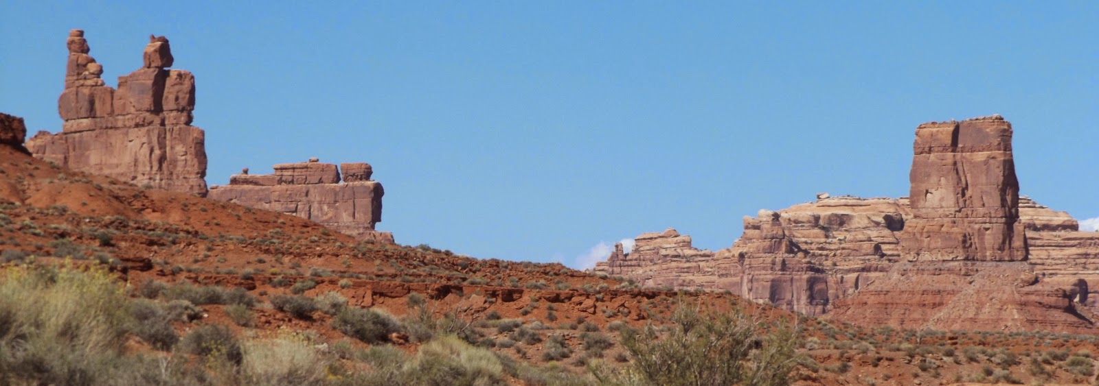
Valley of the Gods . . .
Wearying a tad from a relatively frenetic pace, we opted one day to kick back with a drive through the Valley of the Gods, an area dotted with sandstone monoliths topped by huge boulders tilted at gravity-defying angles. That smaller Monument Valley cousin afforded miles of hiking territory.
 |
| I could feel power emanating from this gargantuan ridge while hiking along its base. |
 |
| I dubbed this ridge Hobbit's Toes. |
 |
| And this one The Sphinx. |
 |
| I love the shadows projected from this ridgeline. |
Of course we took advantage of the wandering opportunity; it seems that when confronted with unexplored countryside, fatigue is no obstacle; I simply can’t help myself.
On one hike, we were thrilled to see a beautiful ghostly pale image from antiquity - a spiral pictograph on a fallen boulder.
 |
| Arizona's well-known Monument Valley is a ghost on the horizon. |
Bed & breakfast . . .
Out in the midst of that landscape dominated by the natural is one lone sign of humanity passing: a ranch house that serves as a bed & breakfast. For a mere $165, a person may avail himself of their hospitality.
 Goosenecks . . .
Because it was not far from the end of our drive through the Valley of the Gods, we took a jaunt out to the so-called Goosenecks of the San Juan for another look at that convoluted river passage.
 |
| This was as close as I cared to venture for a photo op. |
Grand Gulch, Junction Ruin, ob-gyn . . .
During a previous visit here, we stopped in at the Kane Gulch Ranger Station for a little chat about what's in the area. Whatever it was that ranger said really struck my fancy - a hike into the canyon was not possible at the time because of recent flooding, but I have ever after wanted to return, and so we did.
 |
| This familiar creature appeared at the very first part of the hike, so I accepted him as my totem animal/guardian for the day. |
As it turns out, that hike was just about at my limit; however, I did not require a stretcher nor a helicopter at any time. That dadgum Norbert had made a mess there, also; consequently, the trail was pretty much by-guess-and-by golly in most places. The purported hike, thus, could more properly be called a scramble - over and around flood debris, rock slides and fallen boulders of mind-boggling proportions.
The difficulty was matched by the stunning majestic beauty, making the day well worth the effort. In comparison, the hike into Escalante Canyon seems like a walk in the park.
Because much of my enjoyment of adventure is in the sharing through photographs and writing, I am sorely disappointed at the dearth of pictures that are sufficient to convey these recent sights. Obviously a rank amateur photographer at best, the new camera is about to be my undoing. I am sad that my Grand Gulch photos, especially, are so inadequate. It's just too bad that the experimentation/learning process has to be accomplished at such spectacular locations, but such is life.
 |
| The hike began innocuously enough, if somewhat over-vegetated. |
 |
| To try to put the scope of this canyon into perspective: that's Chris down there at the base of "boot rock". |
 |
| Chris is dwarfed in many of these photos. It gives a person an entirely different outlook to be set down amongst these gigantic landscapes. |
 |
| We spied this small ruin tucked up under an overhanging rock slab in an impossibly precarious position, the slit shown in the next photo. |
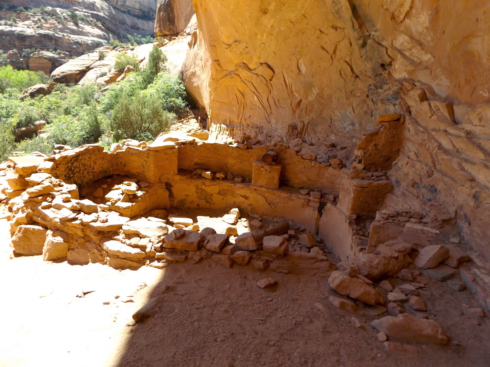
At four miles in, Kane Gulch empties into Grand Gulch, our stated destination. At that confluence, we saw Junction Ruin, an amazing sight ahead dizzyingly far up on the cliff face.
 |
| At the left in this photo is the dangling remains of a ladder used for access. There does not appear to be any other ingress to that section. |
A welcoming canyon bottom oasis just below the upper pueblo obscured sight of
the ruins that were lower on the slope until we were closer. As we
scrambled up the rubbley lower section, we were astounded to see the
extensive ruins there, a site that we could walk right in to.
 |
| A mano and metate - primitive grinding stones. |
 |
| How I yearn to know who were the people who left their handprints on that sandstone wall so long ago and what it meant to them to do so. |
We saw three kivas on that level, one of which had been burned. It appeared that two of them had been excavated, but not the third.
 |
| This kiva view shows a sitting bench bracketed by rock pillar supports for roof beams. |
 |
| A charred upright support beam indicates this kiva burned. |
 |
| This looks down into a ventilator shaft used for air circulation in the kivas. |
The midden, or trash dump, was littered with broken potsherds and hundreds of small corn cobs. Junction is truly one of the most intriguing ruins I’ve ever seen.
We enjoyed late lunch under huge cottonwoods just below the ruin with a fellow hiker, Mike - ob/gyn extraordinaire, or so he told us. We met at the bottom of the gulch and hiked out together, getting acquainted and enjoying the company. There was only one other couple in the canyon the entire day.
While munching our sandwiches, we kept hearing loud rustling in the fallen leaves accumulated in the surrounding brush, and finally realized that we were surrounded by spotted towhees doing their typical vigorous digging followed by jumping backwards to see what they had uncovered. Other birds we've added to the trip list in these relatively unbirdy climes are Brewer's blackbird, Clark's nutcracker, Brewer's sparrow and downy woodpecker.
That lunch break brought us to decision time about whether to proceed downward to Turkey Pen ruin, a course of action I heartily endorsed, of course - after all, “We’ve come this far . . . yada yada yada. Chris wisely nixed the additional two-mile round-trip hike, predicting that I would thank him later. I did.
I had been tripping the light fantastic for the downward half of the trek, and underestimated the hot upward four-mile climb out.
 |
| Mike P., our enthusiastic hiking companion. |
RV park, motorhome mama . . .
We have met a number of interesting good folks on this journey - RV parks are good for that. I had thought our rig was large until a bus-size class A pulled in next to us; we shrank in comparison. That couple was from Payson, Arizona; he was anxious to connect with other Arizonans. He described himself as “anal” when he was handcleaning every square inch of the exterior, and I think I must agree with him. His motorhome looked as if it had just driven off the showroom floor.
The Texans who were next door were very nice and friendly; we all had to laugh about running into each other again out in Utah’s vastness.
Then there was Sherri from Sweet Home, Oregon, a woman of even more advanced age than I. She and her late husband RVed together. After he died, she purchased her current 34-foot motorhome and drives it herself and with a tow vehicle. She was staying next to us in Blanding, had come in with friends in their own rig, said she can’t stand the Oregon winters, so spends that season at various places in Arizona. I am in awe.
The park in Blanding has not much to recommend it except that it allows access to some of the most intriguing country in the world and it does offer a nice view.
 |
| Now in Pagosa Springs, Colorado, a site much more to my liking. |
 |
| Chris read an interesting item about Utah junipers: during times of drought, they can close off circulation, so to speak, to enough limbs to maintain life for the tree itself with what moisture is available. I think this may be an example of that in action. |
 |
| My mind could not comprehend how this ridgeline came to be; it put me in mind of a Navajo blanket design. |
 |
| Off-highway vehicles is a very popular pasttime in Utah's slickrock country. We were astounded to see this example of going whole hog in that direction: a full-size Class A motorhome towing a full-size Toyota Tundra extended cab flatbed truck loaded with a large OHV. Care to guess his gas mileage? |
 |
| These tiny front yard book-share kiosks always make me smile - what a charming way to interact with your neighbors! |
 |
| Bluff claims origins in antiquity. |


No comments:
Post a Comment